Vacchereccia geodata
Vacchereccia (Tuscany) is a populated locality; located in Italy in Europe/Rome (GMT+2) time zone. With population of 1,049 people, there are 6467 cities with bigger population in this country. Compared to other cities in Italy, 59.3% of cities are located further ↑North; 50.6% of cities are located further →East and 62.5% of cities have higher elevation than Vacchereccia. Note1


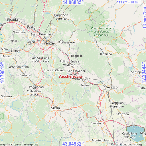
Vacchereccia GPS coordinates[2]
43° 33' 39.564" North, 11° 30' 4.716" East
| Map corner | latitude | longitude |
|---|---|---|
| Upper-left | 44.06835°, | 10.79819° |
| Center: | 43.56099°, | 11.50131° |
| Lower-right: | 43.04932°, | 12.20444° |
| Map W x H: | 113.3×113.3 km | = 70.4×70.4mi |
| max Lat: | 47.04031° ⇑59.3% North |
| Vacchereccia: | 43.56099° |
| min Lat: | ⇓40.7% South 35.50142° |
| min Long | Vacchereccia | max Long |
| 6.69888° | 11.50131° | 18.48682° |
| W 49.4%⇐ | ⇒50.6% E |
Elevation
Elevation of Vacchereccia is 145 m = 476 ft, and this is 161.7 m = 531 ft below average elevation for this country.
| Max E: |
2085 m = 6841 ft | 62.5% |
| Avg. | 306.7 m = 1006 ft | |
| Vacchereccia | 145 m = 476 ft | |
Min E: |
-4 m = -13 ft | 37.5% |
See also: Italy elevation on elevation.city.
Geographical zone
Vacchereccia is located in North temperate zone (between Tropic of Cancer and the Arctic Circle). Distance of this Northern Tropic circle is 2237.6 km =1390.4 mi to South.| Distance of | km | miles | from Vacchereccia |
|---|---|---|---|
| North Pole | 5163.5 | 3208.4 | to North |
| Arctic Circle | 2557.6 | 1589.2 | to North |
| Tropic Cancer | 2237.6 | 1390.4 | to South |
| Equator | 4843.5 | 3009.6 | to South |


Nearby cities:
15 places around Vacchereccia: (largest is in red/bold)
• Castelfranco di Sopra
8.2 km =5.1 mi,  34°
34°
• Castelnuovo dei Sabbioni
4.5 km =2.8 mi,  240°
240°
• Cavriglia-Monastero
4.7 km =2.9 mi,  194°
194°
• Faella
7.4 km =4.6 mi,  10°
10°
• Figline Valdarno
7 km =4.3 mi,  340°
340°
• Madrigale
3.9 km =2.4 mi,  76°
76°
• Meleto
3 km =1.9 mi,  286°
286°
• Montevarchi
7 km =4.3 mi,  124°
124°
• Neri
4.5 km =2.8 mi,  227°
227°
• Penna
8.8 km =5.5 mi,  85°
85°
• Pian di Scò
9.7 km =6 mi,  21°
21°
• San Cipriano-S.Barbara-Centinale
1.6 km =1 mi,  302°
302°
• San Giovanni Valdarno
2.4 km =1.5 mi,  72°
72°
• Terranuova Bracciolini
6.5 km =4 mi,  100°
100°
• Ville
5.7 km =3.5 mi, 84°
Sources, notices
• [Note1] Compared only with cities in Italy existing in our database
• [Src1] Map data: © OpenStreetMap contributors (CC-BY-SA)
• [Src2] Other city data from geonames.org with taken over terms of usage.
• [Src3] Geographical zone / Annual Mean Temperature by Robert A. Rohde @ Wikipedia
