Frignano geodata
Frignano (Campania) is a seat of a third-order administrative division; located in Italy in Europe/Rome (GMT+2) time zone. With population of 8,487 people, there are 1124 cities with bigger population in this country. Compared to other cities in Italy, 78.7% of cities are located further ↑North; 79.6% of cities are located further ←West and 84.4% of cities have higher elevation than Frignano. Note1


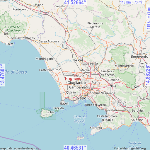
Frignano GPS coordinates[2]
40° 59' 53.196" North, 14° 10' 44.868" East
| Map corner | latitude | longitude |
|---|---|---|
| Upper-left | 41.52664°, | 13.47601° |
| Center: | 40.99811°, | 14.17913° |
| Lower-right: | 40.46531°, | 14.88226° |
| Map W x H: | 118×118 km | = 73.3×73.3mi |
| max Lat: | 47.04031° ⇑78.7% North |
| Frignano: | 40.99811° |
| min Lat: | ⇓21.3% South 35.50142° |
| min Long | Frignano | max Long |
| 6.69888° | 14.17913° | 18.48682° |
| W 79.6%⇐ | ⇒20.4% E |
Elevation
Elevation of Frignano is 33 m = 108 ft, and this is 273.7 m = 898 ft below average elevation for this country.
| Max E: |
2085 m = 6841 ft | 84.4% |
| Avg. | 306.7 m = 1006 ft | |
| Frignano | 33 m = 108 ft | |
Min E: |
-4 m = -13 ft | 15.6% |
See also: Italy elevation on elevation.city.
Geographical zone
Frignano is located in North temperate zone (between Tropic of Cancer and the Arctic Circle). Distance of this Northern Tropic circle is 1952.6 km =1213.3 mi to South.| Distance of | km | miles | from Frignano |
|---|---|---|---|
| North Pole | 5448.5 | 3385.5 | to North |
| Arctic Circle | 2842.6 | 1766.3 | to North |
| Tropic Cancer | 1952.6 | 1213.3 | to South |
| Equator | 4558.6 | 2832.6 | to South |


Nearby cities:
15 places around Frignano: (largest is in red/bold)
• Aversa
3.7 km =2.3 mi,  140°
140°
• Carinaro
3.8 km =2.4 mi,  116°
116°
• Casal di Principe
4.3 km =2.7 mi,  287°
287°
• Casaluce
1.5 km =0.9 mi,  91°
91°
• Casapesenna
3.7 km =2.3 mi,  258°
258°
• Cesa
5.8 km =3.6 mi,  132°
132°
• Gricignano di Aversa
4.8 km =3 mi, 115°
• Lusciano
3.3 km =2.1 mi,  163°
163°
• Parete
4.6 km =2.9 mi,  198°
198°
• San Cipriano d'Aversa
4 km =2.5 mi,  271°
271°
• San Marcellino
0.9 km =0.6 mi, 197°
• Succivo
7.2 km =4.5 mi, 117°
• Teverola
2.4 km =1.5 mi,  96°
96°
• Trentola-Ducenta
2.6 km =1.6 mi,  187°
187°
• Villa di Briano
1.6 km =1 mi,  277°
277°
Sources, notices
• [Note1] Compared only with cities in Italy existing in our database
• [Src1] Map data: © OpenStreetMap contributors (CC-BY-SA)
• [Src2] Other city data from geonames.org with taken over terms of usage.
• [Src3] Geographical zone / Annual Mean Temperature by Robert A. Rohde @ Wikipedia
