Casavatore geodata
Casavatore (Campania) is a seat of a third-order administrative division; located in Italy in Europe/Rome (GMT+2) time zone. With population of 18,663 people, there are 472 cities with bigger population in this country. Compared to other cities in Italy, 80% of cities are located further ↑North; 80.7% of cities are located further ←West and 72.5% of cities have higher elevation than Casavatore. Note1


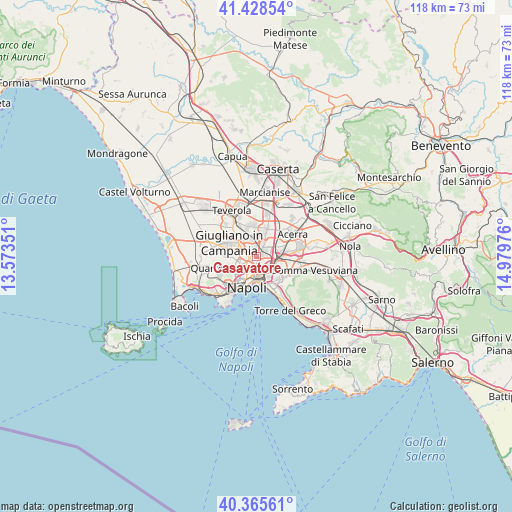
Casavatore GPS coordinates[2]
40° 53' 57.156" North, 14° 16' 35.868" East
| Map corner | latitude | longitude |
|---|---|---|
| Upper-left | 41.42854°, | 13.57351° |
| Center: | 40.89921°, | 14.27663° |
| Lower-right: | 40.36561°, | 14.97976° |
| Map W x H: | 118.2×118.2 km | = 73.4×73.4mi |
| max Lat: | 47.04031° ⇑80% North |
| Casavatore: | 40.89921° |
| min Lat: | ⇓20% South 35.50142° |
| min Long | Casavatore | max Long |
| 6.69888° | 14.27663° | 18.48682° |
| W 80.7%⇐ | ⇒19.3% E |
Elevation
Elevation of Casavatore is 85 m = 279 ft, and this is 221.7 m = 727 ft below average elevation for this country.
| Max E: |
2085 m = 6841 ft | 72.5% |
| Avg. | 306.7 m = 1006 ft | |
| Casavatore | 85 m = 279 ft | |
Min E: |
-4 m = -13 ft | 27.5% |
See also: Italy elevation on elevation.city.
Geographical zone
Casavatore is located in North temperate zone (between Tropic of Cancer and the Arctic Circle). Distance of this Northern Tropic circle is 1941.6 km =1206.5 mi to South.| Distance of | km | miles | from Casavatore |
|---|---|---|---|
| North Pole | 5459.5 | 3392.4 | to North |
| Arctic Circle | 2853.6 | 1773.1 | to North |
| Tropic Cancer | 1941.6 | 1206.5 | to South |
| Equator | 4547.6 | 2825.7 | to South |


Nearby cities:
15 places around Casavatore: (largest is in red/bold)
• Afragola
3.8 km =2.4 mi,  46°
46°
• Arpino
3.8 km =2.4 mi,  107°
107°
• Arzano
1.5 km =0.9 mi,  320°
320°
• Casandrino
4.1 km =2.5 mi, 322°
• Casoria
1.7 km =1.1 mi,  56°
56°
• Grumo Nevano
4.3 km =2.7 mi,  340°
340°
• Melito di Napoli
4.4 km =2.7 mi,  300°
300°
• Miano
2.3 km =1.4 mi,  237°
237°
• Piscinola
3.7 km =2.3 mi,  259°
259°
• Poggioreale
3.9 km =2.4 mi,  164°
164°
• San Carlo All'Arena
4 km =2.5 mi,  196°
196°
• San Pietro a Patierno
1.9 km =1.2 mi,  143°
143°
• Scampia
3.3 km =2.1 mi,  278°
278°
• Secondigliano
0.8 km =0.5 mi, 275°
• Vicaria
4.2 km =2.6 mi,  183°
183°
Sources, notices
• [Note1] Compared only with cities in Italy existing in our database
• [Src1] Map data: © OpenStreetMap contributors (CC-BY-SA)
• [Src2] Other city data from geonames.org with taken over terms of usage.
• [Src3] Geographical zone / Annual Mean Temperature by Robert A. Rohde @ Wikipedia
