Roddino geodata
Roddino (Piedmont) is a seat of a third-order administrative division; located in Italy in Europe/Rome (GMT+2) time zone. With population of 146 people, there are 11295 cities with bigger population in this country. Compared to other cities in Italy, 52.1% of cities are located further ↓South; 93.4% of cities are located further →East and 84.1% of cities have lower elevation than Roddino. Note1


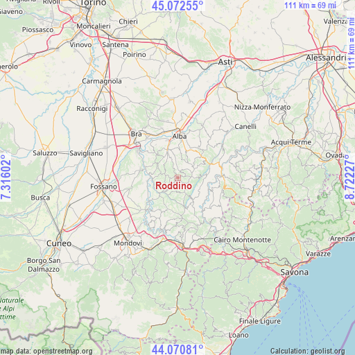
Roddino GPS coordinates[2]
44° 34' 25.824" North, 8° 1' 8.904" East
| Map corner | latitude | longitude |
|---|---|---|
| Upper-left | 45.07255°, | 7.31602° |
| Center: | 44.57384°, | 8.01914° |
| Lower-right: | 44.07081°, | 8.72227° |
| Map W x H: | 111.4×111.4 km | = 69.2×69.2mi |
| max Lat: | 47.04031° ⇑47.9% North |
| Roddino: | 44.57384° |
| min Lat: | ⇓52.1% South 35.50142° |
| min Long | Roddino | max Long |
| 6.69888° | 8.01914° | 18.48682° |
| W 6.6%⇐ | ⇒93.4% E |
Elevation
Elevation of Roddino is 594 m = 1949 ft, and this is 287.3 m = 943 ft above average elevation for this country.
| Max E: |
2085 m = 6841 ft | 15.9% |
| Roddino | 594 m 1949 ft | |
| Avg. | 306.7 m = 1006 ft | |
Min E: |
-4 m = -13 ft | 84.1% |
See also: Italy elevation on elevation.city.
Geographical zone
Roddino is located in North temperate zone (between Tropic of Cancer and the Arctic Circle). Distance of this Northern Tropic circle is 2350.2 km =1460.3 mi to South.| Distance of | km | miles | from Roddino |
|---|---|---|---|
| North Pole | 5050.9 | 3138.5 | to North |
| Arctic Circle | 2445 | 1519.3 | to North |
| Tropic Cancer | 2350.2 | 1460.3 | to South |
| Equator | 4956.1 | 3079.6 | to South |


Nearby cities:
15 places around Roddino: (largest is in red/bold)
• Albaretto della Torre
4.4 km =2.7 mi,  55°
55°
• Arguello
7.3 km =4.5 mi,  82°
82°
• Barolo
7.3 km =4.5 mi,  304°
304°
• Bossolasco
5.6 km =3.5 mi,  154°
154°
• Castiglione Falletto
6.4 km =4 mi,  327°
327°
• Cerreto Langhe
6.2 km =3.9 mi,  88°
88°
• Cissone
1.5 km =0.9 mi,  143°
143°
• Lequio Berria
7.2 km =4.5 mi, 60°
• Monforte d'Alba
4.2 km =2.6 mi,  283°
283°
• Montelupo Albese
5.7 km =3.5 mi,  22°
22°
• Rodello
6.8 km =4.2 mi,  26°
26°
• Serralunga d'Alba
4.3 km =2.7 mi,  338°
338°
• Serravalle Langhe
3.5 km =2.2 mi,  115°
115°
• Sinio
2.9 km =1.8 mi,  1°
1°
• Somano
4.4 km =2.7 mi,  191°
191°
Sources, notices
• [Note1] Compared only with cities in Italy existing in our database
• [Src1] Map data: © OpenStreetMap contributors (CC-BY-SA)
• [Src2] Other city data from geonames.org with taken over terms of usage.
• [Src3] Geographical zone / Annual Mean Temperature by Robert A. Rohde @ Wikipedia
