San Raffaele Cimena geodata
San Raffaele Cimena (Piedmont) is a seat of a third-order administrative division; located in Italy in Europe/Rome (GMT+2) time zone. With population of 2,815 people, there are 3199 cities with bigger population in this country. Compared to other cities in Italy, 63.6% of cities are located further ↓South; 95.2% of cities are located further →East and 56% of cities have higher elevation than San Raffaele Cimena. Note1


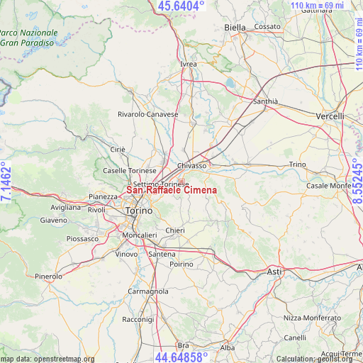
San Raffaele Cimena GPS coordinates[2]
45° 8' 47.94" North, 7° 50' 57.552" East
| Map corner | latitude | longitude |
|---|---|---|
| Upper-left | 45.6404°, | 7.1462° |
| Center: | 45.14665°, | 7.84932° |
| Lower-right: | 44.64858°, | 8.55245° |
| Map W x H: | 110.3×110.3 km | = 68.5×68.5mi |
| max Lat: | 47.04031° ⇑36.4% North |
| San Raffaele Cimena: | 45.14665° |
| min Lat: | ⇓63.6% South 35.50142° |
| min Long | San Raffaele Ci | max Long |
| 6.69888° | 7.84932° | 18.48682° |
| W 4.8%⇐ | ⇒95.2% E |
Elevation
Elevation of San Raffaele Cimena is 195 m = 640 ft, and this is 111.7 m = 366 ft below average elevation for this country.
| Max E: |
2085 m = 6841 ft | 56% |
| Avg. | 306.7 m = 1006 ft | |
| San Raffaele Cimena | 195 m = 640 ft | |
Min E: |
-4 m = -13 ft | 44% |
See also: Italy elevation on elevation.city.
Geographical zone
San Raffaele Cimena is located in North temperate zone (between Tropic of Cancer and the Arctic Circle). Distance of this North polar circle is 2381.3 km =1479.7 mi to North.| Distance of | km | miles | from San Raffaele Cimena |
|---|---|---|---|
| North Pole | 4987.2 | 3098.9 | to North |
| Arctic Circle | 2381.3 | 1479.7 | to North |
| Tropic Cancer | 2413.9 | 1499.9 | to South |
| Equator | 5019.8 | 3119.2 | to South |


Nearby cities:
15 places around San Raffaele Cimena: (largest is in red/bold)
• Brandizzo
3.5 km =2.2 mi,  342°
342°
• Casalborgone
7.4 km =4.6 mi,  104°
104°
• Castagneto Po
3.2 km =2 mi,  65°
65°
• Castiglione Torinese
4.5 km =2.8 mi,  227°
227°
• Chivasso
5.9 km =3.7 mi,  32°
32°
• Cinzano
8.2 km =5.1 mi,  134°
134°
• Gassino Torinese
2.5 km =1.6 mi,  218°
218°
• Pavarolo
8.9 km =5.5 mi,  184°
184°
• Piana San Raffaele
0.7 km =0.4 mi,  5°
5°
• Rivalba
4.5 km =2.8 mi,  137°
137°
• San Mauro Torinese
8 km =5 mi, 233°
• San Sebastiano da Po
8.8 km =5.5 mi, 74°
• Sciolze
6.2 km =3.9 mi,  158°
158°
• Settimo Torinese
6.3 km =3.9 mi,  262°
262°
• Volpiano
8.2 km =5.1 mi,  315°
315°
Sources, notices
• [Note1] Compared only with cities in Italy existing in our database
• [Src1] Map data: © OpenStreetMap contributors (CC-BY-SA)
• [Src2] Other city data from geonames.org with taken over terms of usage.
• [Src3] Geographical zone / Annual Mean Temperature by Robert A. Rohde @ Wikipedia
