Orero geodata
Orero (Liguria) is a seat of a third-order administrative division; located in Italy in Europe/Rome (GMT+2) time zone. With population of 97 people, there are 11453 cities with bigger population in this country. Compared to other cities in Italy, 50.3% of cities are located further ↑North; 77% of cities are located further →East and 73.4% of cities have lower elevation than Orero. Note1


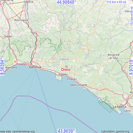
Orero GPS coordinates[2]
44° 24' 30.06" North, 9° 16' 1.452" East
| Map corner | latitude | longitude |
|---|---|---|
| Upper-left | 44.90848°, | 8.56394° |
| Center: | 44.40835°, | 9.26707° |
| Lower-right: | 43.9039°, | 9.97019° |
| Map W x H: | 111.7×111.7 km | = 69.4×69.4mi |
| max Lat: | 47.04031° ⇑50.3% North |
| Orero: | 44.40835° |
| min Lat: | ⇓49.7% South 35.50142° |
| min Long | Orero | max Long |
| 6.69888° | 9.26707° | 18.48682° |
| W 23%⇐ | ⇒77% E |
Elevation
Elevation of Orero is 430 m = 1411 ft, and this is 123.3 m = 405 ft above average elevation for this country.
| Max E: |
2085 m = 6841 ft | 26.6% |
| Orero | 430 m 1411 ft | |
| Avg. | 306.7 m = 1006 ft | |
Min E: |
-4 m = -13 ft | 73.4% |
See also: Italy elevation on elevation.city.
Geographical zone
Orero is located in North temperate zone (between Tropic of Cancer and the Arctic Circle). Distance of this Northern Tropic circle is 2331.8 km =1448.9 mi to South.| Distance of | km | miles | from Orero |
|---|---|---|---|
| North Pole | 5069.3 | 3149.9 | to North |
| Arctic Circle | 2463.4 | 1530.7 | to North |
| Tropic Cancer | 2331.8 | 1448.9 | to South |
| Equator | 4937.7 | 3068.1 | to South |


Nearby cities:
15 places around Orero: (largest is in red/bold)
• Bocco
7 km =4.3 mi,  155°
155°
• Chiesa Nuova
5.6 km =3.5 mi,  140°
140°
• Cicagna
2.2 km =1.4 mi,  266°
266°
• Coreglia Ligure
2.3 km =1.4 mi,  191°
191°
• Favale di Malvaro
4.8 km =3 mi,  353°
353°
• Ferrada
4.7 km =2.9 mi,  286°
286°
• Gattorna
7 km =4.3 mi, 290°
• Leivi
7 km =4.3 mi,  150°
150°
• Lorsica
3 km =1.9 mi,  15°
15°
• Moconesi
4.8 km =3 mi, 286°
• Neirone
7.9 km =4.9 mi,  310°
310°
• Rapallo
7.2 km =4.5 mi,  205°
205°
• Tribogna
5.8 km =3.6 mi,  279°
279°
• Uscio
8.3 km =5.2 mi, 273°
• Zoagli
8 km =5 mi,  180°
180°
Sources, notices
• [Note1] Compared only with cities in Italy existing in our database
• [Src1] Map data: © OpenStreetMap contributors (CC-BY-SA)
• [Src2] Other city data from geonames.org with taken over terms of usage.
• [Src3] Geographical zone / Annual Mean Temperature by Robert A. Rohde @ Wikipedia
