Neirone geodata
Neirone (Liguria) is a seat of a third-order administrative division; located in Italy in Europe/Rome (GMT+2) time zone. With population of 154 people, there are 11267 cities with bigger population in this country. Compared to other cities in Italy, 50.4% of cities are located further ↓South; 78.1% of cities are located further →East and 69.7% of cities have lower elevation than Neirone. Note1


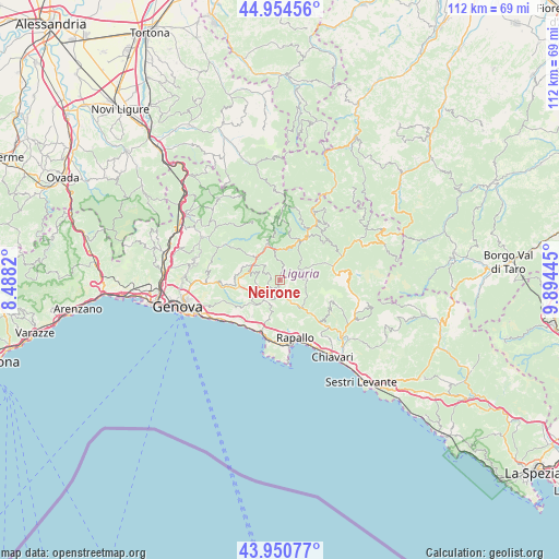
Neirone GPS coordinates[2]
44° 27' 17.352" North, 9° 11' 28.788" East
| Map corner | latitude | longitude |
|---|---|---|
| Upper-left | 44.95456°, | 8.4882° |
| Center: | 44.45482°, | 9.19133° |
| Lower-right: | 43.95077°, | 9.89445° |
| Map W x H: | 111.6×111.6 km | = 69.3×69.3mi |
| max Lat: | 47.04031° ⇑49.6% North |
| Neirone: | 44.45482° |
| min Lat: | ⇓50.4% South 35.50142° |
| min Long | Neirone | max Long |
| 6.69888° | 9.19133° | 18.48682° |
| W 21.9%⇐ | ⇒78.1% E |
Elevation
Elevation of Neirone is 391 m = 1283 ft, and this is 84.3 m = 277 ft above average elevation for this country.
| Max E: |
2085 m = 6841 ft | 30.3% |
| Neirone | 391 m 1283 ft | |
| Avg. | 306.7 m = 1006 ft | |
Min E: |
-4 m = -13 ft | 69.7% |
See also: Italy elevation on elevation.city.
Geographical zone
Neirone is located in North temperate zone (between Tropic of Cancer and the Arctic Circle). Distance of this Northern Tropic circle is 2337 km =1452.1 mi to South.| Distance of | km | miles | from Neirone |
|---|---|---|---|
| North Pole | 5064.1 | 3146.7 | to North |
| Arctic Circle | 2458.3 | 1527.5 | to North |
| Tropic Cancer | 2337 | 1452.1 | to South |
| Equator | 4942.9 | 3071.4 | to South |


Nearby cities:
15 places around Neirone: (largest is in red/bold)
• Avegno
8.4 km =5.2 mi,  198°
198°
• Avegno Chiesa
7.8 km =4.8 mi, 196°
• Bargagli
7.8 km =4.8 mi,  264°
264°
• Cicagna
6.5 km =4 mi,  144°
144°
• Favale di Malvaro
5.5 km =3.4 mi,  93°
93°
• Ferrada
4.1 km =2.5 mi,  158°
158°
• Ferriere
4.5 km =2.8 mi,  253°
253°
• Gattorna
2.7 km =1.7 mi,  190°
190°
• Lorsica
7.2 km =4.5 mi,  108°
108°
• Moconesi
4.1 km =2.5 mi, 158°
• Orero
7.9 km =4.9 mi,  130°
130°
• Testana
7.5 km =4.7 mi,  208°
208°
• Torriglia
7.5 km =4.7 mi,  339°
339°
• Tribogna
4.3 km =2.7 mi,  175°
175°
• Uscio
5.3 km =3.3 mi, 206°
Sources, notices
• [Note1] Compared only with cities in Italy existing in our database
• [Src1] Map data: © OpenStreetMap contributors (CC-BY-SA)
• [Src2] Other city data from geonames.org with taken over terms of usage.
• [Src3] Geographical zone / Annual Mean Temperature by Robert A. Rohde @ Wikipedia
