Bellusco geodata
Bellusco (Lombardy) is a seat of a third-order administrative division; located in Italy in Europe/Rome (GMT+2) time zone. With population of 6,817 people, there are 1435 cities with bigger population in this country. Compared to other cities in Italy, 77.9% of cities are located further ↓South; 74.2% of cities are located further →East and 54.1% of cities have higher elevation than Bellusco. Note1
Administrative division(s):
- Level 1: Lombardy
- Level 2: Provincia di Monza e della Brianza
- Level 3: Bellusco


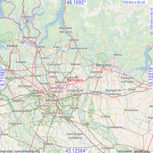
Bellusco GPS coordinates[2]
45° 37' 10.488" North, 9° 25' 8.58" East
| Map corner | latitude | longitude |
|---|---|---|
| Upper-left | 46.1092°, | 8.71593° |
| Center: | 45.61958°, | 9.41905° |
| Lower-right: | 45.12564°, | 10.12218° |
| Map W x H: | 109.4×109.4 km | = 68×68mi |
| max Lat: | 47.04031° ⇑22.1% North |
| Bellusco: | 45.61958° |
| min Lat: | ⇓77.9% South 35.50142° |
| min Long | Bellusco | max Long |
| 6.69888° | 9.41905° | 18.48682° |
| W 25.8%⇐ | ⇒74.2% E |
Elevation
Elevation of Bellusco is 209 m = 686 ft, and this is 97.7 m = 321 ft below average elevation for this country.
| Max E: |
2085 m = 6841 ft | 54.1% |
| Avg. | 306.7 m = 1006 ft | |
| Bellusco | 209 m = 686 ft | |
Min E: |
-4 m = -13 ft | 45.9% |
See also: Italy elevation on elevation.city.
Geographical zone
Bellusco is located in North temperate zone (between Tropic of Cancer and the Arctic Circle). Distance of this North polar circle is 2328.8 km =1447 mi to North.| Distance of | km | miles | from Bellusco |
|---|---|---|---|
| North Pole | 4934.6 | 3066.2 | to North |
| Arctic Circle | 2328.8 | 1447 | to North |
| Tropic Cancer | 2466.5 | 1532.6 | to South |
| Equator | 5072.4 | 3151.8 | to South |


Nearby cities:
15 places around Bellusco: (largest is in red/bold)
• Aicurzio
2.3 km =1.4 mi,  351°
351°
• Bernareggio
3.3 km =2.1 mi,  340°
340°
• Burago di Molgora
3.9 km =2.4 mi,  228°
228°
• Busnago
3.5 km =2.2 mi,  95°
95°
• Cambiago
4.5 km =2.8 mi,  163°
163°
• Carnate
4.5 km =2.8 mi,  315°
315°
• Cavenago di Brianza
4.1 km =2.5 mi,  187°
187°
• Cornate d'Adda
4.4 km =2.7 mi,  77°
77°
• Mezzago
2.3 km =1.4 mi,  62°
62°
• Ornago
2.2 km =1.4 mi,  176°
176°
• Roncello
3.4 km =2.1 mi,  124°
124°
• Sulbiate
2.4 km =1.5 mi,  16°
16°
• Velasca
5.1 km =3.2 mi,  285°
285°
• Villanova
3.1 km =1.9 mi, 317°
• Vimercate
4 km =2.5 mi,  263°
263°
Sources, notices
• [Note1] Compared only with cities in Italy existing in our database
• [Src1] Map data: © OpenStreetMap contributors (CC-BY-SA)
• [Src2] Other city data from geonames.org with taken over terms of usage.
• [Src3] Geographical zone / Annual Mean Temperature by Robert A. Rohde @ Wikipedia
