Roncaro geodata
Roncaro (Lombardy) is a seat of a third-order administrative division; located in Italy in Europe/Rome (GMT+2) time zone. With population of 1,324 people, there are 5557 cities with bigger population in this country. Compared to other cities in Italy, 65.6% of cities are located further ↓South; 76.8% of cities are located further →East and 73.4% of cities have higher elevation than Roncaro. Note1


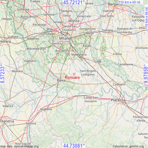
Roncaro GPS coordinates[2]
45° 13' 41.412" North, 9° 16' 31.62" East
| Map corner | latitude | longitude |
|---|---|---|
| Upper-left | 45.72121°, | 8.57233° |
| Center: | 45.22817°, | 9.27545° |
| Lower-right: | 44.73081°, | 9.97858° |
| Map W x H: | 110.1×110.1 km | = 68.4×68.4mi |
| max Lat: | 47.04031° ⇑34.4% North |
| Roncaro: | 45.22817° |
| min Lat: | ⇓65.6% South 35.50142° |
| min Long | Roncaro | max Long |
| 6.69888° | 9.27545° | 18.48682° |
| W 23.2%⇐ | ⇒76.8% E |
Elevation
Elevation of Roncaro is 81 m = 266 ft, and this is 225.7 m = 740 ft below average elevation for this country.
| Max E: |
2085 m = 6841 ft | 73.4% |
| Avg. | 306.7 m = 1006 ft | |
| Roncaro | 81 m = 266 ft | |
Min E: |
-4 m = -13 ft | 26.6% |
See also: Italy elevation on elevation.city.
Geographical zone
Roncaro is located in North temperate zone (between Tropic of Cancer and the Arctic Circle). Distance of this North polar circle is 2372.3 km =1474.1 mi to North.| Distance of | km | miles | from Roncaro |
|---|---|---|---|
| North Pole | 4978.2 | 3093.3 | to North |
| Arctic Circle | 2372.3 | 1474.1 | to North |
| Tropic Cancer | 2423 | 1505.6 | to South |
| Equator | 5028.9 | 3124.8 | to South |


Nearby cities:
15 places around Roncaro: (largest is in red/bold)
• Albuzzano
4.6 km =2.9 mi,  181°
181°
• Calignano
1.8 km =1.1 mi,  164°
164°
• Ceranova
4.4 km =2.7 mi,  324°
324°
• Copiano
5.1 km =3.2 mi,  131°
131°
• Cura Carpignano
2.3 km =1.4 mi,  221°
221°
• Lardirago
3.4 km =2.1 mi,  284°
284°
• Magherno
4.3 km =2.7 mi,  96°
96°
• Marzano
2.7 km =1.7 mi,  34°
34°
• Sant'Alessio Con Vialone
3.9 km =2.4 mi,  260°
260°
• Torre d'Arese
3.7 km =2.3 mi,  63°
63°
• Valera Fratta
5.7 km =3.5 mi, 55°
• Vigalfo
3.7 km =2.3 mi,  171°
171°
• Vigonzone
5.7 km =3.5 mi, 28°
• Vistarino
3.2 km =2 mi, 126°
• Zibido al Lambro
5.7 km =3.5 mi,  358°
358°
Sources, notices
• [Note1] Compared only with cities in Italy existing in our database
• [Src1] Map data: © OpenStreetMap contributors (CC-BY-SA)
• [Src2] Other city data from geonames.org with taken over terms of usage.
• [Src3] Geographical zone / Annual Mean Temperature by Robert A. Rohde @ Wikipedia
