Brione geodata
Brione (Trentino-Alto Adige) is a seat of a third-order administrative division; located in Italy in Europe/Rome (GMT+2) time zone. With population of 142 people, there are 11304 cities with bigger population in this country. Compared to other cities in Italy, 89.1% of cities are located further ↓South; 61.9% of cities are located further →East and 95.6% of cities have lower elevation than Brione. Note1
Administrative division(s):
- Level 1: Trentino-Alto Adige
- Level 2: Provincia autonoma di Trento
- Level 3: Borgo Chiese


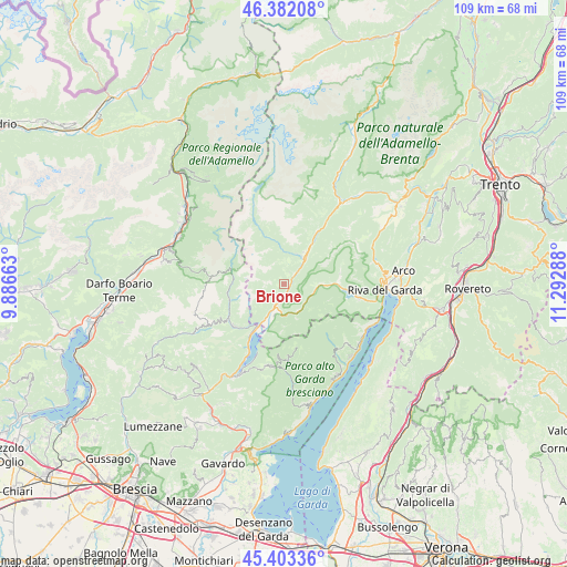
Brione GPS coordinates[2]
45° 53' 41.568" North, 10° 35' 23.1" East
| Map corner | latitude | longitude |
|---|---|---|
| Upper-left | 46.38208°, | 9.88663° |
| Center: | 45.89488°, | 10.58975° |
| Lower-right: | 45.40336°, | 11.29288° |
| Map W x H: | 108.8×108.8 km | = 67.6×67.6mi |
| max Lat: | 47.04031° ⇑10.9% North |
| Brione: | 45.89488° |
| min Lat: | ⇓89.1% South 35.50142° |
| min Long | Brione | max Long |
| 6.69888° | 10.58975° | 18.48682° |
| W 38.1%⇐ | ⇒61.9% E |
Elevation
Elevation of Brione is 907 m = 2976 ft, and this is 600.3 m = 1969 ft above average elevation for this country.
| Max E: |
2085 m = 6841 ft | 4.4% |
| Brione | 907 m 2976 ft | |
| Avg. | 306.7 m = 1006 ft | |
Min E: |
-4 m = -13 ft | 95.6% |
See also: Italy elevation on elevation.city.
Geographical zone
Brione is located in North temperate zone (between Tropic of Cancer and the Arctic Circle). Distance of this North polar circle is 2298.1 km =1428 mi to North.| Distance of | km | miles | from Brione |
|---|---|---|---|
| North Pole | 4904 | 3047.2 | to North |
| Arctic Circle | 2298.1 | 1428 | to North |
| Tropic Cancer | 2497.1 | 1551.6 | to South |
| Equator | 5103 | 3170.9 | to South |


Nearby cities:
15 places around Brione: (largest is in red/bold)
• Bersone
6.4 km =4 mi,  31°
31°
• Castel Condino
2.4 km =1.5 mi,  24°
24°
• Cimego
2.6 km =1.6 mi,  44°
44°
• Condino
1.5 km =0.9 mi,  168°
168°
• Creto
6.5 km =4 mi, 37°
• Daone
6.3 km =3.9 mi, 22°
• Lardaro
10 km =6.2 mi, 33°
• Lodrone-Darzo
8.4 km =5.2 mi,  210°
210°
• Pieve di Bono
6.6 km =4.1 mi, 36°
• Ponte Caffaro
9.6 km =6 mi, 210°
• Praso
7.1 km =4.4 mi, 30°
• Prezzo
5.5 km =3.4 mi, 37°
• Storo
5.1 km =3.2 mi,  188°
188°
• Tiarno di Sopra
6.4 km =4 mi,  93°
93°
• Tiarno di Sotto
7.3 km =4.5 mi, 90°
Sources, notices
• [Note1] Compared only with cities in Italy existing in our database
• [Src1] Map data: © OpenStreetMap contributors (CC-BY-SA)
• [Src2] Other city data from geonames.org with taken over terms of usage.
• [Src3] Geographical zone / Annual Mean Temperature by Robert A. Rohde @ Wikipedia
