Rodengo-Saiano geodata
Rodengo-Saiano (Lombardy) is a seat of a third-order administrative division; located in Italy in Europe/Rome (GMT+2) time zone. With population of 7,507 people, there are 1297 cities with bigger population in this country. Compared to other cities in Italy, 77.1% of cities are located further ↓South; 66.8% of cities are located further →East and 57.9% of cities have higher elevation than Rodengo-Saiano. Note1


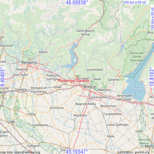
Rodengo-Saiano GPS coordinates[2]
45° 35' 58.488" North, 10° 6' 25.812" East
| Map corner | latitude | longitude |
|---|---|---|
| Upper-left | 46.08938°, | 9.40405° |
| Center: | 45.59958°, | 10.10717° |
| Lower-right: | 45.10547°, | 10.8103° |
| Map W x H: | 109.4×109.4 km | = 68×68mi |
| max Lat: | 47.04031° ⇑22.9% North |
| Rodengo-Saiano: | 45.59958° |
| min Lat: | ⇓77.1% South 35.50142° |
| min Long | Rodengo-Saiano | max Long |
| 6.69888° | 10.10717° | 18.48682° |
| W 33.2%⇐ | ⇒66.8% E |
Elevation
Elevation of Rodengo-Saiano is 180 m = 591 ft, and this is 126.7 m = 416 ft below average elevation for this country.
| Max E: |
2085 m = 6841 ft | 57.9% |
| Avg. | 306.7 m = 1006 ft | |
| Rodengo-Saiano | 180 m = 591 ft | |
Min E: |
-4 m = -13 ft | 42.1% |
See also: Italy elevation on elevation.city.
Geographical zone
Rodengo-Saiano is located in North temperate zone (between Tropic of Cancer and the Arctic Circle). Distance of this North polar circle is 2331 km =1448.4 mi to North.| Distance of | km | miles | from Rodengo-Saiano |
|---|---|---|---|
| North Pole | 4936.9 | 3067.6 | to North |
| Arctic Circle | 2331 | 1448.4 | to North |
| Tropic Cancer | 2464.3 | 1531.2 | to South |
| Equator | 5070.2 | 3150.5 | to South |


Nearby cities:
15 places around Rodengo-Saiano: (largest is in red/bold)
• Bornato
5.2 km =3.2 mi,  262°
262°
• Castegnato
4.3 km =2.7 mi,  172°
172°
• Fontana
2.7 km =1.7 mi,  353°
353°
• Gussago
4.3 km =2.7 mi,  114°
114°
• Monterotondo
5.1 km =3.2 mi,  282°
282°
• Monticelli Brusati
4 km =2.5 mi, 352°
• Ome
3.3 km =2.1 mi,  19°
19°
• Paderno Franciacorta
2.6 km =1.6 mi,  236°
236°
• Parmezzana Calzana
3.9 km =2.4 mi, 346°
• Passirano
2.9 km =1.8 mi, 263°
• Piazza
4 km =2.5 mi, 110°
• Ponte Cingoli
0.2 km =0.1 mi,  185°
185°
• Provezze
4.4 km =2.7 mi,  322°
322°
• Ronco
2.2 km =1.4 mi,  99°
99°
• San Zenone
5.6 km =3.5 mi,  33°
33°
Sources, notices
• [Note1] Compared only with cities in Italy existing in our database
• [Src1] Map data: © OpenStreetMap contributors (CC-BY-SA)
• [Src2] Other city data from geonames.org with taken over terms of usage.
• [Src3] Geographical zone / Annual Mean Temperature by Robert A. Rohde @ Wikipedia
