Castegnato geodata
Castegnato (Lombardy) is a seat of a third-order administrative division; located in Italy in Europe/Rome (GMT+2) time zone. With population of 7,664 people, there are 1269 cities with bigger population in this country. Compared to other cities in Italy, 75.6% of cities are located further ↓South; 66.7% of cities are located further →East and 62.9% of cities have higher elevation than Castegnato. Note1


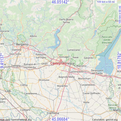
Castegnato GPS coordinates[2]
45° 33' 40.644" North, 10° 6' 52.164" East
| Map corner | latitude | longitude |
|---|---|---|
| Upper-left | 46.05142°, | 9.41137° |
| Center: | 45.56129°, | 10.11449° |
| Lower-right: | 45.06684°, | 10.81762° |
| Map W x H: | 109.5×109.5 km | = 68×68mi |
| max Lat: | 47.04031° ⇑24.4% North |
| Castegnato: | 45.56129° |
| min Lat: | ⇓75.6% South 35.50142° |
| min Long | Castegnato | max Long |
| 6.69888° | 10.11449° | 18.48682° |
| W 33.3%⇐ | ⇒66.7% E |
Elevation
Elevation of Castegnato is 142 m = 466 ft, and this is 164.7 m = 540 ft below average elevation for this country.
| Max E: |
2085 m = 6841 ft | 62.9% |
| Avg. | 306.7 m = 1006 ft | |
| Castegnato | 142 m = 466 ft | |
Min E: |
-4 m = -13 ft | 37.1% |
See also: Italy elevation on elevation.city.
Geographical zone
Castegnato is located in North temperate zone (between Tropic of Cancer and the Arctic Circle). Distance of this North polar circle is 2335.2 km =1451 mi to North.| Distance of | km | miles | from Castegnato |
|---|---|---|---|
| North Pole | 4941.1 | 3070.3 | to North |
| Arctic Circle | 2335.2 | 1451 | to North |
| Tropic Cancer | 2460 | 1528.6 | to South |
| Equator | 5065.9 | 3147.8 | to South |


Nearby cities:
15 places around Castegnato: (largest is in red/bold)
• Cellatica
5.6 km =3.5 mi,  65°
65°
• Costa-Barco
6.4 km =4 mi,  292°
292°
• Fantasina
5.1 km =3.2 mi, 74°
• Gussago
4.1 km =2.5 mi,  53°
53°
• Ospitaletto
3.2 km =2 mi,  251°
251°
• Paderno Franciacorta
3.9 km =2.4 mi,  316°
316°
• Passirano
5.3 km =3.3 mi, 318°
• Piazza
4.3 km =2.7 mi, 47°
• Ponte Cingoli
4.1 km =2.5 mi,  351°
351°
• Rodengo-Saiano
4.3 km =2.7 mi, 352°
• Roncadelle
4.9 km =3 mi,  140°
140°
• Ronco
4.2 km =2.6 mi,  22°
22°
• Segabiello
5.7 km =3.5 mi, 249°
• Torbole Casaglia
5.4 km =3.4 mi,  177°
177°
• Travagliato
4.9 km =3 mi,  212°
212°
Sources, notices
• [Note1] Compared only with cities in Italy existing in our database
• [Src1] Map data: © OpenStreetMap contributors (CC-BY-SA)
• [Src2] Other city data from geonames.org with taken over terms of usage.
• [Src3] Geographical zone / Annual Mean Temperature by Robert A. Rohde @ Wikipedia
