Paroldo geodata
Paroldo (Piedmont) is a seat of a third-order administrative division; located in Italy in Europe/Rome (GMT+1) time zone. With population of 70 people, there are 11538 cities with bigger population in this country. Compared to other cities in Italy, 50% of cities are located further ↓South; 92.7% of cities are located further →East and 86.1% of cities have lower elevation than Paroldo. Note1


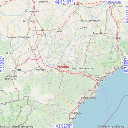
Paroldo GPS coordinates[2]
44° 25' 55.344" North, 8° 4' 20.784" East
| Map corner | latitude | longitude |
|---|---|---|
| Upper-left | 44.93197°, | 7.36932° |
| Center: | 44.43204°, | 8.07244° |
| Lower-right: | 43.9278°, | 8.77557° |
| Map W x H: | 111.7×111.7 km | = 69.4×69.4mi |
| max Lat: | 47.04031° ⇑50% North |
| Paroldo: | 44.43204° |
| min Lat: | ⇓50% South 35.50142° |
| min Long | Paroldo | max Long |
| 6.69888° | 8.07244° | 18.48682° |
| W 7.3%⇐ | ⇒92.7% E |
Elevation
Elevation of Paroldo is 633 m = 2077 ft, and this is 326.3 m = 1071 ft above average elevation for this country.
| Max E: |
2085 m = 6841 ft | 13.9% |
| Paroldo | 633 m 2077 ft | |
| Avg. | 306.7 m = 1006 ft | |
Min E: |
-4 m = -13 ft | 86.1% |
See also: Italy elevation on elevation.city.
Geographical zone
Paroldo is located in North temperate zone (between Tropic of Cancer and the Arctic Circle). Distance of this Northern Tropic circle is 2334.5 km =1450.6 mi to South.| Distance of | km | miles | from Paroldo |
|---|---|---|---|
| North Pole | 5066.7 | 3148.3 | to North |
| Arctic Circle | 2460.8 | 1529.1 | to North |
| Tropic Cancer | 2334.5 | 1450.6 | to South |
| Equator | 4940.4 | 3069.8 | to South |


Nearby cities:
15 places around Paroldo: (largest is in red/bold)
• Camerana
5.6 km =3.5 mi,  99°
99°
• Castellino Tanaro
7.3 km =4.5 mi,  266°
266°
• Ceva
6.3 km =3.9 mi,  214°
214°
• Igliano
4.8 km =3 mi,  284°
284°
• Marsaglia
7.7 km =4.8 mi,  287°
287°
• Mombarcaro
4.2 km =2.6 mi,  17°
17°
• Monesiglio
5.3 km =3.3 mi,  44°
44°
• Murazzano
6.2 km =3.9 mi,  317°
317°
• Priero
6.4 km =4 mi,  165°
165°
• Roascio
4.3 km =2.7 mi,  247°
247°
• Sale San Giovanni
3.7 km =2.3 mi, 173°
• Sale delle Langhe
4.1 km =2.5 mi, 171°
• Saliceto
7.9 km =4.9 mi,  105°
105°
• San Benedetto Belbo
6.6 km =4.1 mi,  349°
349°
• Torresina
2.8 km =1.7 mi, 273°
Sources, notices
• [Note1] Compared only with cities in Italy existing in our database
• [Src1] Map data: © OpenStreetMap contributors (CC-BY-SA)
• [Src2] Other city data from geonames.org with taken over terms of usage.
• [Src3] Geographical zone / Annual Mean Temperature by Robert A. Rohde @ Wikipedia
