Torresina geodata
Torresina (Piedmont) is a seat of a third-order administrative division; located in Italy in Europe/Rome (GMT+2) time zone. With population of 54 people, there are 11593 cities with bigger population in this country. Compared to other cities in Italy, 50.1% of cities are located further ↓South; 93.1% of cities are located further →East and 89.5% of cities have lower elevation than Torresina. Note1


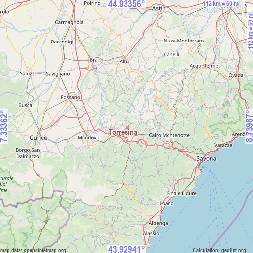
Torresina GPS coordinates[2]
44° 26' 1.104" North, 8° 2' 12.264" East
| Map corner | latitude | longitude |
|---|---|---|
| Upper-left | 44.93356°, | 7.33362° |
| Center: | 44.43364°, | 8.03674° |
| Lower-right: | 43.92941°, | 8.73987° |
| Map W x H: | 111.7×111.6 km | = 69.4×69.3mi |
| max Lat: | 47.04031° ⇑49.9% North |
| Torresina: | 44.43364° |
| min Lat: | ⇓50.1% South 35.50142° |
| min Long | Torresina | max Long |
| 6.69888° | 8.03674° | 18.48682° |
| W 6.9%⇐ | ⇒93.1% E |
Elevation
Elevation of Torresina is 708 m = 2323 ft, and this is 401.3 m = 1317 ft above average elevation for this country.
| Max E: |
2085 m = 6841 ft | 10.5% |
| Torresina | 708 m 2323 ft | |
| Avg. | 306.7 m = 1006 ft | |
Min E: |
-4 m = -13 ft | 89.5% |
See also: Italy elevation on elevation.city.
Geographical zone
Torresina is located in North temperate zone (between Tropic of Cancer and the Arctic Circle). Distance of this Northern Tropic circle is 2334.6 km =1450.7 mi to South.| Distance of | km | miles | from Torresina |
|---|---|---|---|
| North Pole | 5066.5 | 3148.2 | to North |
| Arctic Circle | 2460.6 | 1528.9 | to North |
| Tropic Cancer | 2334.6 | 1450.7 | to South |
| Equator | 4940.6 | 3069.9 | to South |


Nearby cities:
15 places around Torresina: (largest is in red/bold)
• Castellino Tanaro
4.5 km =2.8 mi,  261°
261°
• Ceva
5.5 km =3.4 mi,  187°
187°
• Igliano
2.1 km =1.3 mi,  299°
299°
• Lesegno
6.5 km =4 mi,  235°
235°
• Marsaglia
5 km =3.1 mi, 295°
• Mombarcaro
5.6 km =3.5 mi,  47°
47°
• Monesiglio
7.4 km =4.6 mi,  61°
61°
• Murazzano
4.6 km =2.9 mi,  342°
342°
• Paroldo
2.8 km =1.7 mi,  93°
93°
• Priero
7.8 km =4.8 mi,  144°
144°
• Roascio
2.2 km =1.4 mi,  211°
211°
• Rocca Cigliè
6.9 km =4.3 mi,  280°
280°
• Sale San Giovanni
5 km =3.1 mi, 139°
• Sale delle Langhe
5.5 km =3.4 mi, 141°
• San Benedetto Belbo
6.5 km =4 mi,  14°
14°
Sources, notices
• [Note1] Compared only with cities in Italy existing in our database
• [Src1] Map data: © OpenStreetMap contributors (CC-BY-SA)
• [Src2] Other city data from geonames.org with taken over terms of usage.
• [Src3] Geographical zone / Annual Mean Temperature by Robert A. Rohde @ Wikipedia
