Piovera geodata
Piovera (Piedmont) is a seat of a third-order administrative division; located in Italy in Europe/Rome (GMT+2) time zone. With population of 767 people, there are 7836 cities with bigger population in this country. Compared to other cities in Italy, 59% of cities are located further ↓South; 85% of cities are located further →East and 72.2% of cities have higher elevation than Piovera. Note1
Administrative division(s):
- Level 1: Piedmont
- Level 2: Provincia di Alessandria
- Level 3: Alluvioni Piovera


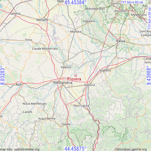
Piovera GPS coordinates[2]
44° 57' 30.42" North, 8° 44' 9.42" East
| Map corner | latitude | longitude |
|---|---|---|
| Upper-left | 45.45384°, | 8.03283° |
| Center: | 44.95845°, | 8.73595° |
| Lower-right: | 44.45875°, | 9.43908° |
| Map W x H: | 110.6×110.6 km | = 68.7×68.7mi |
| max Lat: | 47.04031° ⇑41% North |
| Piovera: | 44.95845° |
| min Lat: | ⇓59% South 35.50142° |
| min Long | Piovera | max Long |
| 6.69888° | 8.73595° | 18.48682° |
| W 15%⇐ | ⇒85% E |
Elevation
Elevation of Piovera is 87 m = 285 ft, and this is 219.7 m = 721 ft below average elevation for this country.
| Max E: |
2085 m = 6841 ft | 72.2% |
| Avg. | 306.7 m = 1006 ft | |
| Piovera | 87 m = 285 ft | |
Min E: |
-4 m = -13 ft | 27.8% |
See also: Italy elevation on elevation.city.
Geographical zone
Piovera is located in North temperate zone (between Tropic of Cancer and the Arctic Circle). Distance of this Northern Tropic circle is 2393 km =1486.9 mi to South.| Distance of | km | miles | from Piovera |
|---|---|---|---|
| North Pole | 5008.2 | 3112 | to North |
| Arctic Circle | 2402.3 | 1492.7 | to North |
| Tropic Cancer | 2393 | 1486.9 | to South |
| Equator | 4998.9 | 3106.2 | to South |


Nearby cities:
15 places around Piovera: (largest is in red/bold)
• Bassignana
4.7 km =2.9 mi,  357°
357°
• Castelceriolo
5.7 km =3.5 mi,  215°
215°
• Gambarana
8.1 km =5 mi,  15°
15°
• Lobbi
3.5 km =2.2 mi,  203°
203°
• Montariolo
5.2 km =3.2 mi,  36°
36°
• Montecastello
4.1 km =2.5 mi,  255°
255°
• Pecetto di Valenza
6.2 km =3.9 mi,  303°
303°
• Pietra Marazzi
5.6 km =3.5 mi,  251°
251°
• Rivarone
2.6 km =1.6 mi,  322°
322°
• Sale
6.2 km =3.9 mi,  68°
68°
• San Giuliano Nuovo
6.1 km =3.8 mi,  161°
161°
• San Giuliano Vecchio
8 km =5 mi,  165°
165°
• Spinetta Marengo
9.3 km =5.8 mi,  209°
209°
• Suardi
8.2 km =5.1 mi,  2°
2°
• Valle San Bartolomeo
7.6 km =4.7 mi, 263°
Sources, notices
• [Note1] Compared only with cities in Italy existing in our database
• [Src1] Map data: © OpenStreetMap contributors (CC-BY-SA)
• [Src2] Other city data from geonames.org with taken over terms of usage.
• [Src3] Geographical zone / Annual Mean Temperature by Robert A. Rohde @ Wikipedia
