Gambarana geodata
Gambarana (Lombardy) is a seat of a third-order administrative division; located in Italy in Europe/Rome (GMT+2) time zone. With population of 195 people, there are 11158 cities with bigger population in this country. Compared to other cities in Italy, 60.7% of cities are located further ↓South; 84.7% of cities are located further →East and 72.8% of cities have higher elevation than Gambarana. Note1


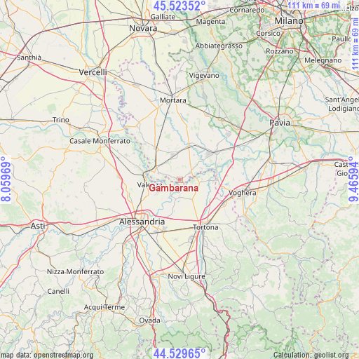
Gambarana GPS coordinates[2]
45° 1' 43.464" North, 8° 45' 46.152" East
| Map corner | latitude | longitude |
|---|---|---|
| Upper-left | 45.52352°, | 8.05969° |
| Center: | 45.02874°, | 8.76282° |
| Lower-right: | 44.52965°, | 9.46594° |
| Map W x H: | 110.5×110.5 km | = 68.7×68.7mi |
| max Lat: | 47.04031° ⇑39.3% North |
| Gambarana: | 45.02874° |
| min Lat: | ⇓60.7% South 35.50142° |
| min Long | Gambarana | max Long |
| 6.69888° | 8.76282° | 18.48682° |
| W 15.3%⇐ | ⇒84.7% E |
Elevation
Elevation of Gambarana is 84 m = 276 ft, and this is 222.7 m = 731 ft below average elevation for this country.
| Max E: |
2085 m = 6841 ft | 72.8% |
| Avg. | 306.7 m = 1006 ft | |
| Gambarana | 84 m = 276 ft | |
Min E: |
-4 m = -13 ft | 27.2% |
See also: Italy elevation on elevation.city.
Geographical zone
Gambarana is located in North temperate zone (between Tropic of Cancer and the Arctic Circle). Distance of this North polar circle is 2394.4 km =1487.8 mi to North.| Distance of | km | miles | from Gambarana |
|---|---|---|---|
| North Pole | 5000.3 | 3107 | to North |
| Arctic Circle | 2394.4 | 1487.8 | to North |
| Tropic Cancer | 2400.8 | 1491.8 | to South |
| Equator | 5006.7 | 3111 | to South |


Nearby cities:
15 places around Gambarana: (largest is in red/bold)
• Bassignana
3.9 km =2.4 mi,  217°
217°
• Frascarolo
6.7 km =4.2 mi,  287°
287°
• Guazzora
6.9 km =4.3 mi,  103°
103°
• Isola Sant'Antonio
6.8 km =4.2 mi,  88°
88°
• Mede
7.8 km =4.8 mi,  344°
344°
• Mezzana Bigli
7.5 km =4.7 mi,  62°
62°
• Montariolo
3.8 km =2.4 mi,  164°
164°
• Pecetto di Valenza
8.5 km =5.3 mi,  238°
238°
• Pieve del Cairo
3.9 km =2.4 mi,  54°
54°
• Piovera
8.1 km =5 mi,  195°
195°
• Rivarone
6.9 km =4.3 mi,  212°
212°
• Sale
6.6 km =4.1 mi,  146°
146°
• Suardi
1.7 km =1.1 mi,  283°
283°
• Torre Beretti
8 km =5 mi,  295°
295°
• Villa Biscossi
7.1 km =4.4 mi,  15°
15°
Sources, notices
• [Note1] Compared only with cities in Italy existing in our database
• [Src1] Map data: © OpenStreetMap contributors (CC-BY-SA)
• [Src2] Other city data from geonames.org with taken over terms of usage.
• [Src3] Geographical zone / Annual Mean Temperature by Robert A. Rohde @ Wikipedia
