Laino geodata
Laino (Lombardy) is a seat of a third-order administrative division; located in Italy in Europe/Rome (GMT+2) time zone. With population of 506 people, there are 9871 cities with bigger population in this country. Compared to other cities in Italy, 91.6% of cities are located further ↓South; 80.1% of cities are located further →East and 88.4% of cities have lower elevation than Laino. Note1


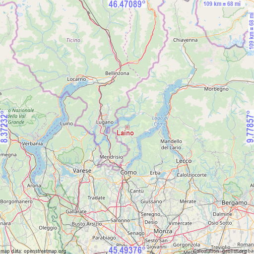
Laino GPS coordinates[2]
45° 59' 4.128" North, 9° 4' 31.584" East
| Map corner | latitude | longitude |
|---|---|---|
| Upper-left | 46.47089°, | 8.37232° |
| Center: | 45.98448°, | 9.07544° |
| Lower-right: | 45.49376°, | 9.77857° |
| Map W x H: | 108.6×108.6 km | = 67.5×67.5mi |
| max Lat: | 47.04031° ⇑8.4% North |
| Laino: | 45.98448° |
| min Lat: | ⇓91.6% South 35.50142° |
| min Long | Laino | max Long |
| 6.69888° | 9.07544° | 18.48682° |
| W 19.9%⇐ | ⇒80.1% E |
Elevation
Elevation of Laino is 680 m = 2231 ft, and this is 373.3 m = 1225 ft above average elevation for this country.
| Max E: |
2085 m = 6841 ft | 11.6% |
| Laino | 680 m 2231 ft | |
| Avg. | 306.7 m = 1006 ft | |
Min E: |
-4 m = -13 ft | 88.4% |
See also: Italy elevation on elevation.city.
Geographical zone
Laino is located in North temperate zone (between Tropic of Cancer and the Arctic Circle). Distance of this North polar circle is 2288.2 km =1421.8 mi to North.| Distance of | km | miles | from Laino |
|---|---|---|---|
| North Pole | 4894.1 | 3041.1 | to North |
| Arctic Circle | 2288.2 | 1421.8 | to North |
| Tropic Cancer | 2507.1 | 1557.8 | to South |
| Equator | 5113 | 3177.1 | to South |


Nearby cities:
15 places around Laino: (largest is in red/bold)
• Blessagno
3.3 km =2.1 mi,  148°
148°
• Casasco Intelvi
4.5 km =2.8 mi,  179°
179°
• Castiglione d'Intelvi
3.2 km =2 mi,  159°
159°
• Cerano d'Intelvi
4.5 km =2.8 mi,  168°
168°
• Dizzasco-Biazzeno
4.9 km =3 mi, 157°
• Lanzo d'Intelvi
4.2 km =2.6 mi,  262°
262°
• Osteno
2.6 km =1.6 mi,  14°
14°
• Osteno-Claino
2.3 km =1.4 mi,  23°
23°
• Pellio Intelvi
1.4 km =0.9 mi,  248°
248°
• Pigra
5 km =3.1 mi,  127°
127°
• Ponna Superiore
1.5 km =0.9 mi,  68°
68°
• Ramponio Verna
1.6 km =1 mi,  333°
333°
• San Fedele Intelvi
1.9 km =1.2 mi, 167°
• San Fedele Superiore
2.1 km =1.3 mi,  198°
198°
• San Mamete
4.8 km =3 mi,  339°
339°
Sources, notices
• [Note1] Compared only with cities in Italy existing in our database
• [Src1] Map data: © OpenStreetMap contributors (CC-BY-SA)
• [Src2] Other city data from geonames.org with taken over terms of usage.
• [Src3] Geographical zone / Annual Mean Temperature by Robert A. Rohde @ Wikipedia
