Ragoli geodata
Ragoli (Trentino-Alto Adige) is a seat of a third-order administrative division; located in Italy in Europe/Rome (GMT+2) time zone. With population of 425 people, there are 10181 cities with bigger population in this country. Compared to other cities in Italy, 93.1% of cities are located further ↓South; 60% of cities are located further →East and 82.8% of cities have lower elevation than Ragoli. Note1
Administrative division(s):
- Level 1: Trentino-Alto Adige
- Level 2: Provincia autonoma di Trento
- Level 3: Tre Ville


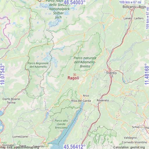
Ragoli GPS coordinates[2]
46° 3' 15.228" North, 10° 46' 42.78" East
| Map corner | latitude | longitude |
|---|---|---|
| Upper-left | 46.54003°, | 10.07543° |
| Center: | 46.05423°, | 10.77855° |
| Lower-right: | 45.56412°, | 11.48168° |
| Map W x H: | 108.5×108.5 km | = 67.4×67.4mi |
| max Lat: | 47.04031° ⇑6.9% North |
| Ragoli: | 46.05423° |
| min Lat: | ⇓93.1% South 35.50142° |
| min Long | Ragoli | max Long |
| 6.69888° | 10.77855° | 18.48682° |
| W 40%⇐ | ⇒60% E |
Elevation
Elevation of Ragoli is 569 m = 1867 ft, and this is 262.3 m = 861 ft above average elevation for this country.
| Max E: |
2085 m = 6841 ft | 17.2% |
| Ragoli | 569 m 1867 ft | |
| Avg. | 306.7 m = 1006 ft | |
Min E: |
-4 m = -13 ft | 82.8% |
See also: Italy elevation on elevation.city.
Geographical zone
Ragoli is located in North temperate zone (between Tropic of Cancer and the Arctic Circle). Distance of this North polar circle is 2280.4 km =1417 mi to North.| Distance of | km | miles | from Ragoli |
|---|---|---|---|
| North Pole | 4886.3 | 3036.2 | to North |
| Arctic Circle | 2280.4 | 1417 | to North |
| Tropic Cancer | 2514.8 | 1562.6 | to South |
| Equator | 5120.8 | 3181.9 | to South |


Nearby cities:
15 places around Ragoli: (largest is in red/bold)
• Bleggio Superiore
5.7 km =3.5 mi,  125°
125°
• Bocenago
7.3 km =4.5 mi,  348°
348°
• Bolbeno
4 km =2.5 mi,  232°
232°
• Fiavè
7.4 km =4.6 mi,  138°
138°
• Montagne
2.2 km =1.4 mi,  282°
282°
• Pelugo
5.7 km =3.5 mi,  312°
312°
• Ponte Arche
7.6 km =4.7 mi,  106°
106°
• Preore
1.7 km =1.1 mi,  239°
239°
• Spiazzo
6.3 km =3.9 mi,  331°
331°
• Stenico
6 km =3.7 mi,  93°
93°
• Strembo
7.7 km =4.8 mi,  343°
343°
• Tione di Trento
4.5 km =2.8 mi, 242°
• Vigo Rendena
5.3 km =3.3 mi,  302°
302°
• Villa Rendena
5.2 km =3.2 mi, 280°
• Zuclo
3.1 km =1.9 mi,  223°
223°
Sources, notices
• [Note1] Compared only with cities in Italy existing in our database
• [Src1] Map data: © OpenStreetMap contributors (CC-BY-SA)
• [Src2] Other city data from geonames.org with taken over terms of usage.
• [Src3] Geographical zone / Annual Mean Temperature by Robert A. Rohde @ Wikipedia
