Valgrisenche geodata
Valgrisenche (Aosta Valley) is a seat of a third-order administrative division; located in Italy in Europe/Rome (GMT+2) time zone. With population of 49 people, there are 11606 cities with bigger population in this country. Compared to other cities in Italy, 78.3% of cities are located further ↓South; 99.7% of cities are located further →East and 99.9% of cities have lower elevation than Valgrisenche. Note1


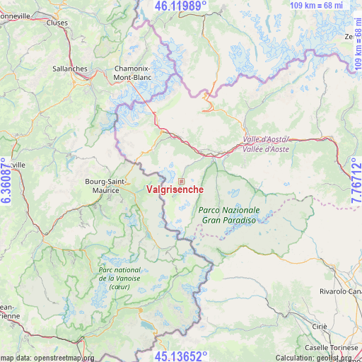
Valgrisenche GPS coordinates[2]
45° 37' 49.296" North, 7° 3' 50.4" East
| Map corner | latitude | longitude |
|---|---|---|
| Upper-left | 46.11989°, | 6.36087° |
| Center: | 45.63036°, | 7.064° |
| Lower-right: | 45.13652°, | 7.76712° |
| Map W x H: | 109.3×109.3 km | = 67.9×67.9mi |
| max Lat: | 47.04031° ⇑21.7% North |
| Valgrisenche: | 45.63036° |
| min Lat: | ⇓78.3% South 35.50142° |
| min Long | Valgrisenche | max Long |
| 6.69888° | 7.064° | 18.48682° |
| W 0.3%⇐ | ⇒99.7% E |
Elevation
Elevation of Valgrisenche is 1662 m = 5453 ft, and this is 1355.3 m = 4447 ft above average elevation for this country.
| Max E: |
2085 m = 6841 ft | 0.099999999999994% |
| Valgrisenche | 1662 m 5453 ft | |
| Avg. | 306.7 m = 1006 ft | |
Min E: |
-4 m = -13 ft | 99.9% |
See also: Italy elevation on elevation.city.
Geographical zone
Valgrisenche is located in North temperate zone (between Tropic of Cancer and the Arctic Circle). Distance of this North polar circle is 2327.6 km =1446.3 mi to North.| Distance of | km | miles | from Valgrisenche |
|---|---|---|---|
| North Pole | 4933.4 | 3065.5 | to North |
| Arctic Circle | 2327.6 | 1446.3 | to North |
| Tropic Cancer | 2467.7 | 1533.4 | to South |
| Equator | 5073.6 | 3152.6 | to South |


Nearby cities:
15 places around Valgrisenche: (largest is in red/bold)
• Arvier
11.1 km =6.9 mi,  43°
43°
• Avise
10.5 km =6.5 mi,  34°
34°
• Aymavilles
16.2 km =10.1 mi,  60°
60°
• Introd
11.5 km =7.1 mi,  52°
52°
• La Salle
12.8 km =8 mi,  3°
3°
• La Thuile
12.8 km =8 mi,  316°
316°
• Morgex
14.2 km =8.8 mi,  352°
352°
• Plan d'Introd
11.5 km =7.1 mi, 53°
• Prè Saint Didier
16.1 km =10 mi,  337°
337°
• Rhemes-Notre-Dame
8 km =5 mi,  147°
147°
• Rhemes-Saint-Georges
7.4 km =4.6 mi,  70°
70°
• Saint-Nicolas
12.5 km =7.8 mi, 39°
• Saint-Pierre
15.5 km =9.6 mi, 54°
• Valsavarenche
12.1 km =7.5 mi,  110°
110°
• Villeneuve
13.7 km =8.5 mi, 54°
Sources, notices
• [Note1] Compared only with cities in Italy existing in our database
• [Src1] Map data: © OpenStreetMap contributors (CC-BY-SA)
• [Src2] Other city data from geonames.org with taken over terms of usage.
• [Src3] Geographical zone / Annual Mean Temperature by Robert A. Rohde @ Wikipedia
