Morgex geodata
Morgex (Aosta Valley) is a seat of a third-order administrative division; located in Italy in Europe/Rome (GMT+2) time zone. With population of 1,741 people, there are 4591 cities with bigger population in this country. Compared to other cities in Italy, 83.9% of cities are located further ↓South; 99.8% of cities are located further →East and 95.9% of cities have lower elevation than Morgex. Note1


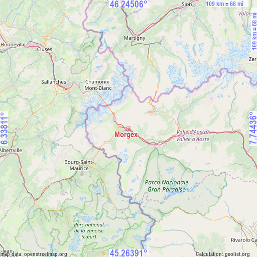
Morgex GPS coordinates[2]
45° 45' 23.904" North, 7° 2' 28.428" East
| Map corner | latitude | longitude |
|---|---|---|
| Upper-left | 46.24506°, | 6.33811° |
| Center: | 45.75664°, | 7.04123° |
| Lower-right: | 45.26391°, | 7.74436° |
| Map W x H: | 109.1×109.1 km | = 67.8×67.8mi |
| max Lat: | 47.04031° ⇑16.1% North |
| Morgex: | 45.75664° |
| min Lat: | ⇓83.9% South 35.50142° |
| min Long | Morgex | max Long |
| 6.69888° | 7.04123° | 18.48682° |
| W 0.2%⇐ | ⇒99.8% E |
Elevation
Elevation of Morgex is 931 m = 3054 ft, and this is 624.3 m = 2048 ft above average elevation for this country.
| Max E: |
2085 m = 6841 ft | 4.1% |
| Morgex | 931 m 3054 ft | |
| Avg. | 306.7 m = 1006 ft | |
Min E: |
-4 m = -13 ft | 95.9% |
See also: Italy elevation on elevation.city.
Geographical zone
Morgex is located in North temperate zone (between Tropic of Cancer and the Arctic Circle). Distance of this North polar circle is 2313.5 km =1437.5 mi to North.| Distance of | km | miles | from Morgex |
|---|---|---|---|
| North Pole | 4919.4 | 3056.8 | to North |
| Arctic Circle | 2313.5 | 1437.5 | to North |
| Tropic Cancer | 2481.7 | 1542.1 | to South |
| Equator | 5087.7 | 3161.3 | to South |


Nearby cities:
15 places around Morgex: (largest is in red/bold)
• Arvier
11.2 km =7 mi,  122°
122°
• Avise
9.3 km =5.8 mi, 124°
• Courmayeur
7.2 km =4.5 mi,  308°
308°
• Introd
13 km =8.1 mi, 122°
• La Salle
2.8 km =1.7 mi, 117°
• La Thuile
8.5 km =5.3 mi,  235°
235°
• Plan d'Introd
13.2 km =8.2 mi, 123°
• Prè Saint Didier
4.4 km =2.7 mi,  281°
281°
• Rhemes-Saint-Georges
14.6 km =9.1 mi,  142°
142°
• Saint-Nicolas
10.7 km =6.6 mi,  114°
114°
• Saint-Oyen
15.3 km =9.5 mi,  60°
60°
• Saint-Rhémy
14.1 km =8.8 mi,  51°
51°
• San Leonardo
13.2 km =8.2 mi, 55°
• Valgrisenche
14.2 km =8.8 mi,  172°
172°
• Villeneuve
14.2 km =8.8 mi, 115°
Sources, notices
• [Note1] Compared only with cities in Italy existing in our database
• [Src1] Map data: © OpenStreetMap contributors (CC-BY-SA)
• [Src2] Other city data from geonames.org with taken over terms of usage.
• [Src3] Geographical zone / Annual Mean Temperature by Robert A. Rohde @ Wikipedia
