Lambrugo geodata
Lambrugo (Lombardy) is a seat of a third-order administrative division; located in Italy in Europe/Rome (GMT+2) time zone. With population of 2,455 people, there are 3579 cities with bigger population in this country. Compared to other cities in Italy, 84% of cities are located further ↓South; 77.4% of cities are located further →East and 59.3% of cities have lower elevation than Lambrugo. Note1


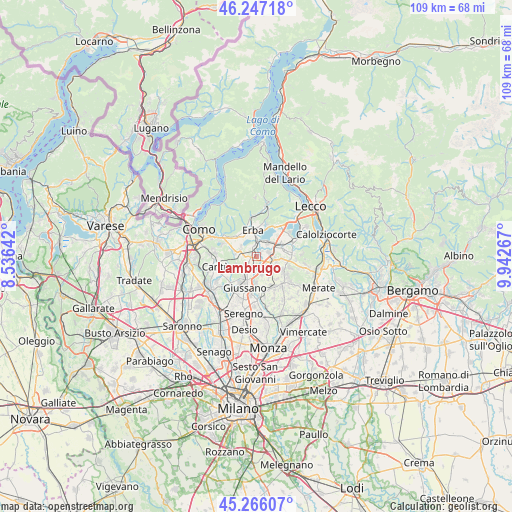
Lambrugo GPS coordinates[2]
45° 45' 31.608" North, 9° 14' 22.344" East
| Map corner | latitude | longitude |
|---|---|---|
| Upper-left | 46.24718°, | 8.53642° |
| Center: | 45.75878°, | 9.23954° |
| Lower-right: | 45.26607°, | 9.94267° |
| Map W x H: | 109.1×109.1 km | = 67.8×67.8mi |
| max Lat: | 47.04031° ⇑16% North |
| Lambrugo: | 45.75878° |
| min Lat: | ⇓84% South 35.50142° |
| min Long | Lambrugo | max Long |
| 6.69888° | 9.23954° | 18.48682° |
| W 22.6%⇐ | ⇒77.4% E |
Elevation
Elevation of Lambrugo is 294 m = 965 ft, and this is 12.7 m = 42 ft below average elevation for this country.
| Max E: |
2085 m = 6841 ft | 40.7% |
| Avg. | 306.7 m = 1006 ft | |
| Lambrugo | 294 m = 965 ft | |
Min E: |
-4 m = -13 ft | 59.3% |
See also: Italy elevation on elevation.city.
Geographical zone
Lambrugo is located in North temperate zone (between Tropic of Cancer and the Arctic Circle). Distance of this North polar circle is 2313.3 km =1437.4 mi to North.| Distance of | km | miles | from Lambrugo |
|---|---|---|---|
| North Pole | 4919.2 | 3056.6 | to North |
| Arctic Circle | 2313.3 | 1437.4 | to North |
| Tropic Cancer | 2482 | 1542.2 | to South |
| Equator | 5087.9 | 3161.5 | to South |


Nearby cities:
15 places around Lambrugo: (largest is in red/bold)
• Anzano del Parco
3.5 km =2.2 mi,  291°
291°
• Bulciago
3.7 km =2.3 mi,  104°
104°
• Camisasca
1.5 km =0.9 mi,  53°
53°
• Costa Masnaga
3.1 km =1.9 mi,  67°
67°
• Fabbrica Durini
3.5 km =2.2 mi,  255°
255°
• Fornaci
3.6 km =2.2 mi,  178°
178°
• Gaggio
2 km =1.2 mi,  139°
139°
• Inverigo
2.8 km =1.7 mi,  215°
215°
• Lurago d'Erba
1.9 km =1.2 mi,  242°
242°
• Merone
3.2 km =2 mi,  6°
6°
• Nibionno
2.7 km =1.7 mi,  120°
120°
• Nobile-Monguzzo
2.5 km =1.6 mi,  343°
343°
• Rogeno
3.7 km =2.3 mi, 45°
• Tabiago-Cibrone
2.1 km =1.3 mi, 97°
• Veduggio Con Colzano
3.7 km =2.3 mi, 139°
Sources, notices
• [Note1] Compared only with cities in Italy existing in our database
• [Src1] Map data: © OpenStreetMap contributors (CC-BY-SA)
• [Src2] Other city data from geonames.org with taken over terms of usage.
• [Src3] Geographical zone / Annual Mean Temperature by Robert A. Rohde @ Wikipedia
