Fabbrica Durini geodata
Fabbrica Durini (Lombardy) is a populated place; located in Italy in Europe/Rome (GMT+2) time zone. With population of 890 people, there are 7207 cities with bigger population in this country. Compared to other cities in Italy, 83.6% of cities are located further ↓South; 78.1% of cities are located further →East and 63.3% of cities have lower elevation than Fabbrica Durini. Note1


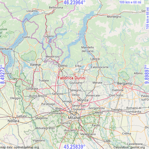
Fabbrica Durini GPS coordinates[2]
45° 45' 4.212" North, 9° 11' 45.024" East
| Map corner | latitude | longitude |
|---|---|---|
| Upper-left | 46.23964°, | 8.49272° |
| Center: | 45.75117°, | 9.19584° |
| Lower-right: | 45.25839°, | 9.89897° |
| Map W x H: | 109.1×109.1 km | = 67.8×67.8mi |
| max Lat: | 47.04031° ⇑16.4% North |
| Fabbrica Durini: | 45.75117° |
| min Lat: | ⇓83.6% South 35.50142° |
| min Long | Fabbrica Durini | max Long |
| 6.69888° | 9.19584° | 18.48682° |
| W 21.9%⇐ | ⇒78.1% E |
Elevation
Elevation of Fabbrica Durini is 326 m = 1070 ft, and this is 19.3 m = 63 ft above average elevation for this country.
| Max E: |
2085 m = 6841 ft | 36.7% |
| Fabbrica Durini | 326 m 1070 ft | |
| Avg. | 306.7 m = 1006 ft | |
Min E: |
-4 m = -13 ft | 63.3% |
See also: Italy elevation on elevation.city.
Geographical zone
Fabbrica Durini is located in North temperate zone (between Tropic of Cancer and the Arctic Circle). Distance of this North polar circle is 2314.1 km =1437.9 mi to North.| Distance of | km | miles | from Fabbrica Durini |
|---|---|---|---|
| North Pole | 4920 | 3057.1 | to North |
| Arctic Circle | 2314.1 | 1437.9 | to North |
| Tropic Cancer | 2481.1 | 1541.7 | to South |
| Equator | 5087.1 | 3161 | to South |


Nearby cities:
15 places around Fabbrica Durini: (largest is in red/bold)
• Alserio
3.1 km =1.9 mi,  6°
6°
• Alzate Brianza
2.3 km =1.4 mi,  332°
332°
• Anzano del Parco
2.1 km =1.3 mi,  3°
3°
• Arosio
3.7 km =2.3 mi,  164°
164°
• Brenna
1.1 km =0.7 mi,  219°
219°
• Camisasca
5 km =3.1 mi,  69°
69°
• Carugo
4.7 km =2.9 mi,  179°
179°
• Fornaci
4.4 km =2.7 mi,  128°
128°
• Gaggio
4.8 km =3 mi,  98°
98°
• Inverigo
2.3 km =1.4 mi, 130°
• Lambrugo
3.5 km =2.2 mi,  75°
75°
• Lurago d'Erba
1.7 km =1.1 mi,  90°
90°
• Nobile-Monguzzo
4.2 km =2.6 mi,  39°
39°
• Orsenigo
3.3 km =2.1 mi,  337°
337°
• Vill'Albese
5.1 km =3.2 mi,  353°
353°
Sources, notices
• [Note1] Compared only with cities in Italy existing in our database
• [Src1] Map data: © OpenStreetMap contributors (CC-BY-SA)
• [Src2] Other city data from geonames.org with taken over terms of usage.
• [Src3] Geographical zone / Annual Mean Temperature by Robert A. Rohde @ Wikipedia
