Bezzecca geodata
Bezzecca (Trentino-Alto Adige) is a populated place; located in Italy in Europe/Rome (GMT+2) time zone. With population of 610 people, there are 8915 cities with bigger population in this country. Compared to other cities in Italy, 89.2% of cities are located further ↓South; 60.8% of cities are located further →East and 89.2% of cities have lower elevation than Bezzecca. Note1
Administrative division(s):
- Level 1: Trentino-Alto Adige
- Level 2: Provincia autonoma di Trento
- Level 3: Ledro


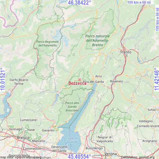
Bezzecca GPS coordinates[2]
45° 53' 49.344" North, 10° 43' 5.988" East
| Map corner | latitude | longitude |
|---|---|---|
| Upper-left | 46.38422°, | 10.01521° |
| Center: | 45.89704°, | 10.71833° |
| Lower-right: | 45.40554°, | 11.42146° |
| Map W x H: | 108.8×108.8 km | = 67.6×67.6mi |
| max Lat: | 47.04031° ⇑10.8% North |
| Bezzecca: | 45.89704° |
| min Lat: | ⇓89.2% South 35.50142° |
| min Long | Bezzecca | max Long |
| 6.69888° | 10.71833° | 18.48682° |
| W 39.2%⇐ | ⇒60.8% E |
Elevation
Elevation of Bezzecca is 699 m = 2293 ft, and this is 392.3 m = 1287 ft above average elevation for this country.
| Max E: |
2085 m = 6841 ft | 10.8% |
| Bezzecca | 699 m 2293 ft | |
| Avg. | 306.7 m = 1006 ft | |
Min E: |
-4 m = -13 ft | 89.2% |
See also: Italy elevation on elevation.city.
Geographical zone
Bezzecca is located in North temperate zone (between Tropic of Cancer and the Arctic Circle). Distance of this North polar circle is 2297.9 km =1427.8 mi to North.| Distance of | km | miles | from Bezzecca |
|---|---|---|---|
| North Pole | 4903.8 | 3047.1 | to North |
| Arctic Circle | 2297.9 | 1427.8 | to North |
| Tropic Cancer | 2497.4 | 1551.8 | to South |
| Equator | 5103.3 | 3171 | to South |


Nearby cities:
15 places around Bezzecca: (largest is in red/bold)
• Bersone
8.4 km =5.2 mi,  308°
308°
• Castel Condino
9.1 km =5.7 mi,  282°
282°
• Cimego
8.3 km =5.2 mi, 281°
• Concei
1.3 km =0.8 mi,  39°
39°
• Creto
7.8 km =4.8 mi, 309°
• Daone
9.4 km =5.8 mi, 306°
• Lardaro
9.2 km =5.7 mi,  331°
331°
• Molina di Ledro
5.2 km =3.2 mi,  123°
123°
• Pieve di Bono
7.9 km =4.9 mi, 309°
• Pieve di Ledro
1.4 km =0.9 mi,  133°
133°
• Praso
8.7 km =5.4 mi, 312°
• Prezzo
7.8 km =4.8 mi,  302°
302°
• Tenno
9.1 km =5.7 mi,  74°
74°
• Tiarno di Sopra
3.6 km =2.2 mi,  259°
259°
• Tiarno di Sotto
2.6 km =1.6 mi, 263°
Sources, notices
• [Note1] Compared only with cities in Italy existing in our database
• [Src1] Map data: © OpenStreetMap contributors (CC-BY-SA)
• [Src2] Other city data from geonames.org with taken over terms of usage.
• [Src3] Geographical zone / Annual Mean Temperature by Robert A. Rohde @ Wikipedia
