Comignago geodata
Comignago (Piedmont) is a seat of a third-order administrative division; located in Italy in Europe/Rome (GMT+2) time zone. With population of 752 people, there are 7941 cities with bigger population in this country. Compared to other cities in Italy, 81.9% of cities are located further ↓South; 87.2% of cities are located further →East and 56.4% of cities have lower elevation than Comignago. Note1


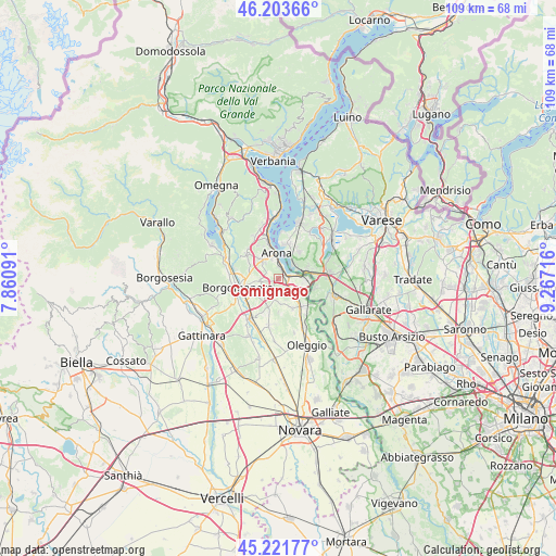
Comignago GPS coordinates[2]
45° 42' 53.532" North, 8° 33' 50.508" East
| Map corner | latitude | longitude |
|---|---|---|
| Upper-left | 46.20366°, | 7.86091° |
| Center: | 45.71487°, | 8.56403° |
| Lower-right: | 45.22177°, | 9.26716° |
| Map W x H: | 109.2×109.2 km | = 67.9×67.9mi |
| max Lat: | 47.04031° ⇑18.1% North |
| Comignago: | 45.71487° |
| min Lat: | ⇓81.9% South 35.50142° |
| min Long | Comignago | max Long |
| 6.69888° | 8.56403° | 18.48682° |
| W 12.8%⇐ | ⇒87.2% E |
Elevation
Elevation of Comignago is 274 m = 899 ft, and this is 32.7 m = 107 ft below average elevation for this country.
| Max E: |
2085 m = 6841 ft | 43.6% |
| Avg. | 306.7 m = 1006 ft | |
| Comignago | 274 m = 899 ft | |
Min E: |
-4 m = -13 ft | 56.4% |
See also: Italy elevation on elevation.city.
Geographical zone
Comignago is located in North temperate zone (between Tropic of Cancer and the Arctic Circle). Distance of this North polar circle is 2318.2 km =1440.5 mi to North.| Distance of | km | miles | from Comignago |
|---|---|---|---|
| North Pole | 4924 | 3059.6 | to North |
| Arctic Circle | 2318.2 | 1440.5 | to North |
| Tropic Cancer | 2477.1 | 1539.2 | to South |
| Equator | 5083 | 3158.4 | to South |


Nearby cities:
15 places around Comignago: (largest is in red/bold)
• Agrate
4.4 km =2.7 mi,  183°
183°
• Agrate Conturbia
4.4 km =2.7 mi, 184°
• Arona
4.9 km =3 mi,  353°
353°
• Barquedo
6.1 km =3.8 mi,  300°
300°
• Bogogno
6.2 km =3.9 mi,  201°
201°
• Borgo Ticino
4.2 km =2.6 mi,  132°
132°
• Castelletto Sopra Ticino
5.4 km =3.4 mi,  83°
83°
• Dormelletto
2.4 km =1.5 mi,  4°
4°
• Gattico
3.5 km =2.2 mi,  255°
255°
• Lisanza
3.8 km =2.4 mi,  44°
44°
• Oleggio Castello
4.7 km =2.9 mi,  322°
322°
• Paruzzaro
5.3 km =3.3 mi,  314°
314°
• Revislate
2.5 km =1.6 mi, 199°
• Sesto Calende
5.6 km =3.5 mi, 77°
• Veruno
4 km =2.5 mi,  223°
223°
Sources, notices
• [Note1] Compared only with cities in Italy existing in our database
• [Src1] Map data: © OpenStreetMap contributors (CC-BY-SA)
• [Src2] Other city data from geonames.org with taken over terms of usage.
• [Src3] Geographical zone / Annual Mean Temperature by Robert A. Rohde @ Wikipedia
