Piatto geodata
Piatto (Piedmont) is a seat of a third-order administrative division; located in Italy in Europe/Rome (GMT+2) time zone. With population of 402 people, there are 10271 cities with bigger population in this country. Compared to other cities in Italy, 76.6% of cities are located further ↓South; 91.8% of cities are located further →East and 68.9% of cities have lower elevation than Piatto. Note1


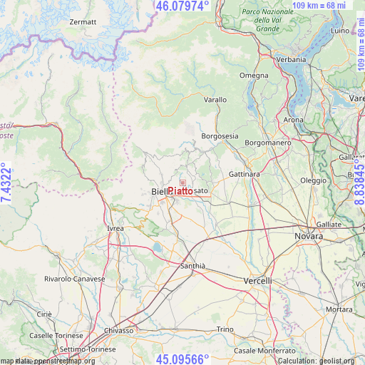
Piatto GPS coordinates[2]
45° 35' 23.496" North, 8° 8' 7.152" East
| Map corner | latitude | longitude |
|---|---|---|
| Upper-left | 46.07974°, | 7.4322° |
| Center: | 45.58986°, | 8.13532° |
| Lower-right: | 45.09566°, | 8.83845° |
| Map W x H: | 109.4×109.4 km | = 68×68mi |
| max Lat: | 47.04031° ⇑23.4% North |
| Piatto: | 45.58986° |
| min Lat: | ⇓76.6% South 35.50142° |
| min Long | Piatto | max Long |
| 6.69888° | 8.13532° | 18.48682° |
| W 8.2%⇐ | ⇒91.8% E |
Elevation
Elevation of Piatto is 383 m = 1257 ft, and this is 76.3 m = 250 ft above average elevation for this country.
| Max E: |
2085 m = 6841 ft | 31.1% |
| Piatto | 383 m 1257 ft | |
| Avg. | 306.7 m = 1006 ft | |
Min E: |
-4 m = -13 ft | 68.9% |
See also: Italy elevation on elevation.city.
Geographical zone
Piatto is located in North temperate zone (between Tropic of Cancer and the Arctic Circle). Distance of this North polar circle is 2332.1 km =1449.1 mi to North.| Distance of | km | miles | from Piatto |
|---|---|---|---|
| North Pole | 4937.9 | 3068.3 | to North |
| Arctic Circle | 2332.1 | 1449.1 | to North |
| Tropic Cancer | 2463.2 | 1530.6 | to South |
| Equator | 5069.1 | 3149.8 | to South |


Nearby cities:
15 places around Piatto: (largest is in red/bold)
• Bioglio-Portula-Andrè
2.8 km =1.7 mi,  1°
1°
• Cerreto Castello
3.5 km =2.2 mi,  144°
144°
• Cossato
4.4 km =2.7 mi,  119°
119°
• Fontanella-Ozino
4.2 km =2.6 mi,  38°
38°
• Livera
3.4 km =2.1 mi,  317°
317°
• Maglione-Crosa
1.8 km =1.1 mi, 36°
• Pettinengo
3.5 km =2.2 mi, 316°
• Quaregna
2.4 km =1.5 mi,  113°
113°
• Ronco Biellese
3.7 km =2.3 mi,  249°
249°
• Ternengo
1.7 km =1.1 mi,  266°
266°
• Valdengo
2.5 km =1.6 mi,  174°
174°
• Vallanzengo
1.9 km =1.2 mi, 38°
• Valle San Nicolao
2 km =1.2 mi,  13°
13°
• Vigliano Biellese
3.8 km =2.4 mi,  218°
218°
• Zumaglia
3.6 km =2.2 mi,  277°
277°
Sources, notices
• [Note1] Compared only with cities in Italy existing in our database
• [Src1] Map data: © OpenStreetMap contributors (CC-BY-SA)
• [Src2] Other city data from geonames.org with taken over terms of usage.
• [Src3] Geographical zone / Annual Mean Temperature by Robert A. Rohde @ Wikipedia
