Cavaglietto geodata
Cavaglietto (Piedmont) is a seat of a third-order administrative division; located in Italy in Europe/Rome (GMT+2) time zone. With population of 320 people, there are 10595 cities with bigger population in this country. Compared to other cities in Italy, 77.2% of cities are located further ↓South; 87.9% of cities are located further →East and 50.4% of cities have lower elevation than Cavaglietto. Note1


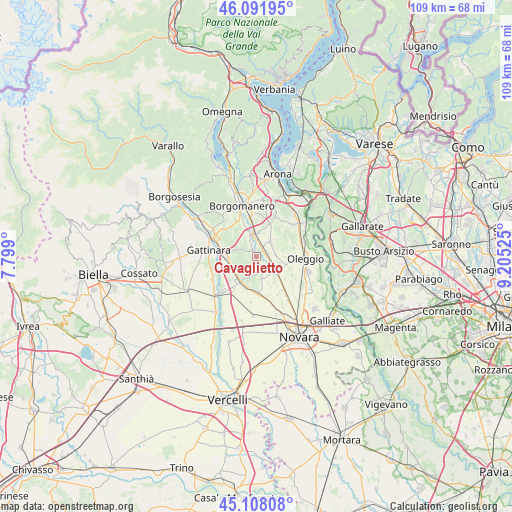
Cavaglietto GPS coordinates[2]
45° 36' 7.812" North, 8° 30' 7.668" East
| Map corner | latitude | longitude |
|---|---|---|
| Upper-left | 46.09195°, | 7.799° |
| Center: | 45.60217°, | 8.50213° |
| Lower-right: | 45.10808°, | 9.20525° |
| Map W x H: | 109.4×109.4 km | = 68×68mi |
| max Lat: | 47.04031° ⇑22.8% North |
| Cavaglietto: | 45.60217° |
| min Lat: | ⇓77.2% South 35.50142° |
| min Long | Cavaglietto | max Long |
| 6.69888° | 8.50213° | 18.48682° |
| W 12.1%⇐ | ⇒87.9% E |
Elevation
Elevation of Cavaglietto is 237 m = 778 ft, and this is 69.7 m = 229 ft below average elevation for this country.
| Max E: |
2085 m = 6841 ft | 49.6% |
| Avg. | 306.7 m = 1006 ft | |
| Cavaglietto | 237 m = 778 ft | |
Min E: |
-4 m = -13 ft | 50.4% |
See also: Italy elevation on elevation.city.
Geographical zone
Cavaglietto is located in North temperate zone (between Tropic of Cancer and the Arctic Circle). Distance of this North polar circle is 2330.7 km =1448.2 mi to North.| Distance of | km | miles | from Cavaglietto |
|---|---|---|---|
| North Pole | 4936.6 | 3067.5 | to North |
| Arctic Circle | 2330.7 | 1448.2 | to North |
| Tropic Cancer | 2464.6 | 1531.4 | to South |
| Equator | 5070.5 | 3150.7 | to South |


Nearby cities:
15 places around Cavaglietto: (largest is in red/bold)
• Baraggia
2.3 km =1.4 mi,  35°
35°
• Baraggione
5.1 km =3.2 mi,  357°
357°
• Barengo
3.1 km =1.9 mi,  162°
162°
• Bogogno
7.2 km =4.5 mi,  20°
20°
• Briona
6.9 km =4.3 mi,  194°
194°
• Cavaglio D'Agogna
1.7 km =1.1 mi,  314°
314°
• Cressa
5.1 km =3.2 mi,  6°
6°
• Fara Novarese
6.4 km =4 mi,  213°
213°
• Fontaneto D'Agogna
4.9 km =3 mi,  338°
338°
• Ghemme
6.4 km =4 mi,  266°
266°
• Mezzomerico
8.3 km =5.2 mi,  76°
76°
• Momo
5.1 km =3.2 mi,  127°
127°
• Sizzano
5.9 km =3.7 mi,  241°
241°
• Suno
4.6 km =2.9 mi,  45°
45°
• Vaprio D'Agogna
4 km =2.5 mi,  88°
88°
Sources, notices
• [Note1] Compared only with cities in Italy existing in our database
• [Src1] Map data: © OpenStreetMap contributors (CC-BY-SA)
• [Src2] Other city data from geonames.org with taken over terms of usage.
• [Src3] Geographical zone / Annual Mean Temperature by Robert A. Rohde @ Wikipedia
