Baraggia geodata
Baraggia (Piedmont) is a populated place; located in Italy in Europe/Rome (GMT+2) time zone. With population of 682 people, there are 8413 cities with bigger population in this country. Compared to other cities in Italy, 77.8% of cities are located further ↓South; 87.8% of cities are located further →East and 51.4% of cities have lower elevation than Baraggia. Note1


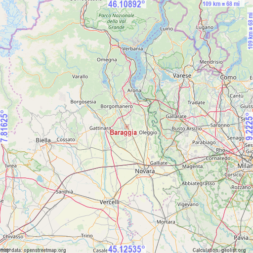
Baraggia GPS coordinates[2]
45° 37' 9.444" North, 8° 31' 9.732" East
| Map corner | latitude | longitude |
|---|---|---|
| Upper-left | 46.10892°, | 7.81625° |
| Center: | 45.61929°, | 8.51937° |
| Lower-right: | 45.12535°, | 9.2225° |
| Map W x H: | 109.4×109.4 km | = 68×68mi |
| max Lat: | 47.04031° ⇑22.2% North |
| Baraggia: | 45.61929° |
| min Lat: | ⇓77.8% South 35.50142° |
| min Long | Baraggia | max Long |
| 6.69888° | 8.51937° | 18.48682° |
| W 12.2%⇐ | ⇒87.8% E |
Elevation
Elevation of Baraggia is 243 m = 797 ft, and this is 63.7 m = 209 ft below average elevation for this country.
| Max E: |
2085 m = 6841 ft | 48.6% |
| Avg. | 306.7 m = 1006 ft | |
| Baraggia | 243 m = 797 ft | |
Min E: |
-4 m = -13 ft | 51.4% |
See also: Italy elevation on elevation.city.
Geographical zone
Baraggia is located in North temperate zone (between Tropic of Cancer and the Arctic Circle). Distance of this North polar circle is 2328.8 km =1447 mi to North.| Distance of | km | miles | from Baraggia |
|---|---|---|---|
| North Pole | 4934.7 | 3066.3 | to North |
| Arctic Circle | 2328.8 | 1447 | to North |
| Tropic Cancer | 2466.5 | 1532.6 | to South |
| Equator | 5072.4 | 3151.8 | to South |


Nearby cities:
15 places around Baraggia: (largest is in red/bold)
• Agrate
7 km =4.3 mi,  27°
27°
• Agrate Conturbia
7 km =4.3 mi, 26°
• Baraggione
3.5 km =2.2 mi,  333°
333°
• Barengo
4.8 km =3 mi,  184°
184°
• Bogogno
5 km =3.1 mi,  13°
13°
• Cavaglietto
2.3 km =1.4 mi,  215°
215°
• Cavaglio D'Agogna
2.7 km =1.7 mi,  255°
255°
• Cressa
3.2 km =2 mi,  346°
346°
• Cureggio
7.7 km =4.8 mi,  323°
323°
• Fontaneto D'Agogna
4.1 km =2.5 mi,  310°
310°
• Fornaci
7.4 km =4.6 mi,  111°
111°
• Mezzomerico
6.7 km =4.2 mi,  89°
89°
• Momo
5.7 km =3.5 mi,  151°
151°
• Suno
2.4 km =1.5 mi,  55°
55°
• Vaprio D'Agogna
3.2 km =2 mi,  123°
123°
Sources, notices
• [Note1] Compared only with cities in Italy existing in our database
• [Src1] Map data: © OpenStreetMap contributors (CC-BY-SA)
• [Src2] Other city data from geonames.org with taken over terms of usage.
• [Src3] Geographical zone / Annual Mean Temperature by Robert A. Rohde @ Wikipedia
