Farigliano geodata
Farigliano (Piedmont) is a seat of a third-order administrative division; located in Italy in Europe/Rome (GMT+2) time zone. With population of 1,043 people, there are 6489 cities with bigger population in this country. Compared to other cities in Italy, 51.2% of cities are located further ↓South; 94.6% of cities are located further →East and 54.9% of cities have lower elevation than Farigliano. Note1


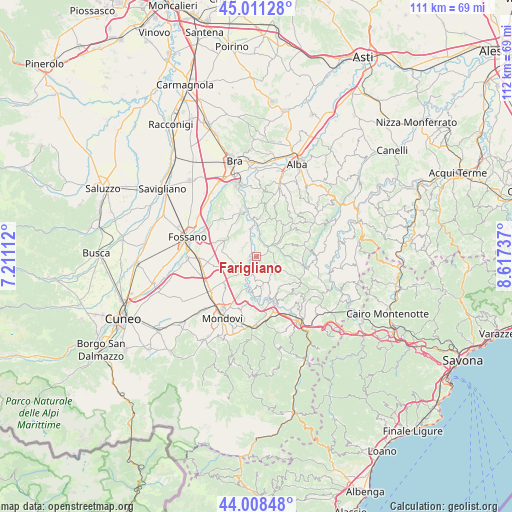
Farigliano GPS coordinates[2]
44° 30' 43.344" North, 7° 54' 51.264" East
| Map corner | latitude | longitude |
|---|---|---|
| Upper-left | 45.01128°, | 7.21112° |
| Center: | 44.51204°, | 7.91424° |
| Lower-right: | 44.00848°, | 8.61737° |
| Map W x H: | 111.5×111.5 km | = 69.3×69.3mi |
| max Lat: | 47.04031° ⇑48.8% North |
| Farigliano: | 44.51204° |
| min Lat: | ⇓51.2% South 35.50142° |
| min Long | Farigliano | max Long |
| 6.69888° | 7.91424° | 18.48682° |
| W 5.4%⇐ | ⇒94.6% E |
Elevation
Elevation of Farigliano is 265 m = 869 ft, and this is 41.7 m = 137 ft below average elevation for this country.
| Max E: |
2085 m = 6841 ft | 45.1% |
| Avg. | 306.7 m = 1006 ft | |
| Farigliano | 265 m = 869 ft | |
Min E: |
-4 m = -13 ft | 54.9% |
See also: Italy elevation on elevation.city.
Geographical zone
Farigliano is located in North temperate zone (between Tropic of Cancer and the Arctic Circle). Distance of this Northern Tropic circle is 2343.4 km =1456.1 mi to South.| Distance of | km | miles | from Farigliano |
|---|---|---|---|
| North Pole | 5057.8 | 3142.8 | to North |
| Arctic Circle | 2451.9 | 1523.5 | to North |
| Tropic Cancer | 2343.4 | 1456.1 | to South |
| Equator | 4949.3 | 3075.4 | to South |


Nearby cities:
15 places around Farigliano: (largest is in red/bold)
• Bastia Mondovì
8 km =5 mi,  191°
191°
• Belvedere Langhe
5.2 km =3.2 mi,  113°
113°
• Bene Vagienna
7.7 km =4.8 mi,  296°
296°
• Bonvicino
8.2 km =5.1 mi,  96°
96°
• Carrù
4.9 km =3 mi,  222°
222°
• Cigliè
8.5 km =5.3 mi,  173°
173°
• Clavesana
3.2 km =2 mi,  184°
184°
• Dogliani
3.4 km =2.1 mi,  46°
46°
• Lequio Tanaro
5.9 km =3.7 mi,  334°
334°
• Marsaglia
8.4 km =5.2 mi,  141°
141°
• Monchiero Borgonuovo
6.5 km =4 mi,  4°
4°
• Novello
8.6 km =5.3 mi,  6°
6°
• Piozzo
1.7 km =1.1 mi,  276°
276°
• Rocca Cigliè
8 km =5 mi,  158°
158°
• Somano
7.9 km =4.9 mi,  70°
70°
Sources, notices
• [Note1] Compared only with cities in Italy existing in our database
• [Src1] Map data: © OpenStreetMap contributors (CC-BY-SA)
• [Src2] Other city data from geonames.org with taken over terms of usage.
• [Src3] Geographical zone / Annual Mean Temperature by Robert A. Rohde @ Wikipedia
