Majano geodata
Majano (Friuli Venezia Giulia) is a seat of a third-order administrative division; located in Italy in Europe/Rome (GMT+2) time zone. With population of 5,690 people, there are 1728 cities with bigger population in this country. Compared to other cities in Italy, 95.9% of cities are located further ↓South; 69% of cities are located further ←West and 59.4% of cities have higher elevation than Majano. Note1
Administrative division(s):
- Level 1: Friuli Venezia Giulia
- Level 2: Provincia di Udine
- Level 3: Majano


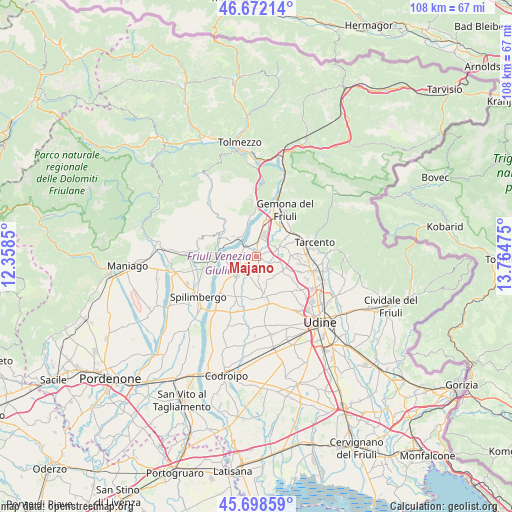
Majano GPS coordinates[2]
46° 11' 15.072" North, 13° 3' 41.832" East
| Map corner | latitude | longitude |
|---|---|---|
| Upper-left | 46.67214°, | 12.3585° |
| Center: | 46.18752°, | 13.06162° |
| Lower-right: | 45.69859°, | 13.76475° |
| Map W x H: | 108.2×108.2 km | = 67.2×67.2mi |
| max Lat: | 47.04031° ⇑4.1% North |
| Majano: | 46.18752° |
| min Lat: | ⇓95.9% South 35.50142° |
| min Long | Majano | max Long |
| 6.69888° | 13.06162° | 18.48682° |
| W 69%⇐ | ⇒31% E |
Elevation
Elevation of Majano is 168 m = 551 ft, and this is 138.7 m = 455 ft below average elevation for this country.
| Max E: |
2085 m = 6841 ft | 59.4% |
| Avg. | 306.7 m = 1006 ft | |
| Majano | 168 m = 551 ft | |
Min E: |
-4 m = -13 ft | 40.6% |
See also: Italy elevation on elevation.city.
Geographical zone
Majano is located in North temperate zone (between Tropic of Cancer and the Arctic Circle). Distance of this North polar circle is 2265.6 km =1407.8 mi to North.| Distance of | km | miles | from Majano |
|---|---|---|---|
| North Pole | 4871.5 | 3027 | to North |
| Arctic Circle | 2265.6 | 1407.8 | to North |
| Tropic Cancer | 2529.7 | 1571.9 | to South |
| Equator | 5135.6 | 3191.1 | to South |


Nearby cities:
15 places around Majano: (largest is in red/bold)
• Buia
5.1 km =3.2 mi,  57°
57°
• Caporiacco
5.2 km =3.2 mi,  152°
152°
• Colloredo di Monte Albano
6.4 km =4 mi,  113°
113°
• Colloredo di Monte Albano-Lauzzana
5.7 km =3.5 mi,  124°
124°
• Forgaria nel Friuli
7.6 km =4.7 mi,  298°
298°
• Madrisio
7.6 km =4.7 mi,  181°
181°
• Mels
3.9 km =2.4 mi, 108°
• Muris
5.1 km =3.2 mi,  271°
271°
• Osoppo
7.7 km =4.8 mi,  13°
13°
• Rive d'Arcano
7.1 km =4.4 mi,  198°
198°
• San Daniele del Friuli
5.4 km =3.4 mi,  231°
231°
• San Giacomo
6.2 km =3.9 mi,  255°
255°
• Santo Stefano
5.5 km =3.4 mi, 64°
• Treppo Grande
7.2 km =4.5 mi,  79°
79°
• Vendoglio-Carvacco
7.1 km =4.4 mi,  97°
97°
Sources, notices
• [Note1] Compared only with cities in Italy existing in our database
• [Src1] Map data: © OpenStreetMap contributors (CC-BY-SA)
• [Src2] Other city data from geonames.org with taken over terms of usage.
• [Src3] Geographical zone / Annual Mean Temperature by Robert A. Rohde @ Wikipedia
