Calvi geodata
Calvi (Campania) is a seat of a third-order administrative division; located in Italy in Europe/Rome (GMT+2) time zone. With population of 827 people, there are 7518 cities with bigger population in this country. Compared to other cities in Italy, 77.8% of cities are located further ↑North; 86.1% of cities are located further ←West and 67.1% of cities have lower elevation than Calvi. Note1


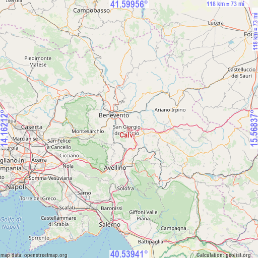
Calvi GPS coordinates[2]
41° 4' 17.832" North, 14° 51' 54.864" East
| Map corner | latitude | longitude |
|---|---|---|
| Upper-left | 41.59956°, | 14.16212° |
| Center: | 41.07162°, | 14.86524° |
| Lower-right: | 40.53941°, | 15.56837° |
| Map W x H: | 117.9×117.9 km | = 73.3×73.3mi |
| max Lat: | 47.04031° ⇑77.8% North |
| Calvi: | 41.07162° |
| min Lat: | ⇓22.2% South 35.50142° |
| min Long | Calvi | max Long |
| 6.69888° | 14.86524° | 18.48682° |
| W 86.1%⇐ | ⇒13.9% E |
Elevation
Elevation of Calvi is 364 m = 1194 ft, and this is 57.3 m = 188 ft above average elevation for this country.
| Max E: |
2085 m = 6841 ft | 32.9% |
| Calvi | 364 m 1194 ft | |
| Avg. | 306.7 m = 1006 ft | |
Min E: |
-4 m = -13 ft | 67.1% |
See also: Italy elevation on elevation.city.
Geographical zone
Calvi is located in North temperate zone (between Tropic of Cancer and the Arctic Circle). Distance of this Northern Tropic circle is 1960.8 km =1218.4 mi to South.| Distance of | km | miles | from Calvi |
|---|---|---|---|
| North Pole | 5440.3 | 3380.4 | to North |
| Arctic Circle | 2834.4 | 1761.2 | to North |
| Tropic Cancer | 1960.8 | 1218.4 | to South |
| Equator | 4566.7 | 2837.6 | to South |


Nearby cities:
15 places around Calvi: (largest is in red/bold)
• Campanarello
4.9 km =3 mi,  123°
123°
• Cesine
1.5 km =0.9 mi,  350°
350°
• Iannassi-Bosco Perrotta
3.4 km =2.1 mi,  309°
309°
• Maccoli-Perrillo
5.3 km =3.3 mi,  289°
289°
• Montefusco
4 km =2.5 mi,  192°
192°
• Pastene
4.5 km =2.8 mi, 285°
• Pietradefusi
3.5 km =2.2 mi,  153°
153°
• San Giacomo
2.1 km =1.3 mi,  238°
238°
• San Giorgio del Sannio
1.1 km =0.7 mi,  250°
250°
• San Martino Sannita
2.6 km =1.6 mi, 254°
• San Nazzaro
2.3 km =1.4 mi,  196°
196°
• San Nicola Manfredi
3.5 km =2.2 mi,  276°
276°
• Sant'Angelo A Cupolo
5.2 km =3.2 mi,  266°
266°
• Sant'Elena Irpina
4.3 km =2.7 mi, 152°
• Venticano
4.8 km =3 mi, 124°
Sources, notices
• [Note1] Compared only with cities in Italy existing in our database
• [Src1] Map data: © OpenStreetMap contributors (CC-BY-SA)
• [Src2] Other city data from geonames.org with taken over terms of usage.
• [Src3] Geographical zone / Annual Mean Temperature by Robert A. Rohde @ Wikipedia
