Iannassi-Bosco Perrotta geodata
Iannassi-Bosco Perrotta (Campania) is a populated place; located in Italy in Europe/Rome (GMT+2) time zone. With population of 932 people, there are 6974 cities with bigger population in this country. Compared to other cities in Italy, 77.5% of cities are located further ↑North; 85.8% of cities are located further ←West and 60.2% of cities have lower elevation than Iannassi-Bosco Perrotta. Note1
Administrative division(s):
- Level 1: Campania
- Level 2: Provincia di Benevento
- Level 3: San Nicola Manfredi
Current local time in Iannassi-Bosco Perrotta:
07:24 PM, WednesdayDifference from your time zone: hours


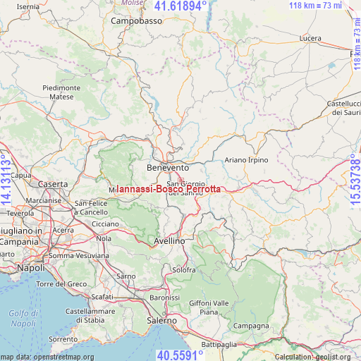
Iannassi-Bosco Perrotta GPS coordinates[2]
41° 5' 28.176" North, 14° 50' 3.3" East
| Map corner | latitude | longitude |
|---|---|---|
| Upper-left | 41.61894°, | 14.13113° |
| Center: | 41.09116°, | 14.83425° |
| Lower-right: | 40.5591°, | 15.53738° |
| Map W x H: | 117.8×117.8 km | = 73.2×73.2mi |
| max Lat: | 47.04031° ⇑77.5% North |
| Iannassi-Bosco Perrotta: | 41.09116° |
| min Lat: | ⇓22.5% South 35.50142° |
| min Long | Iannassi-Bosco | max Long |
| 6.69888° | 14.83425° | 18.48682° |
| W 85.8%⇐ | ⇒14.2% E |
Elevation
Elevation of Iannassi-Bosco Perrotta is 300 m = 984 ft, and this is 6.7 m = 22 ft below average elevation for this country.
| Max E: |
2085 m = 6841 ft | 39.8% |
| Avg. | 306.7 m = 1006 ft | |
| Iannassi-Bosco Perrotta | 300 m = 984 ft | |
Min E: |
-4 m = -13 ft | 60.2% |
See also: Italy elevation on elevation.city.
Geographical zone
Iannassi-Bosco Perrotta is located in North temperate zone (between Tropic of Cancer and the Arctic Circle). Distance of this Northern Tropic circle is 1963 km =1219.8 mi to South.| Distance of | km | miles | from Iannassi-Bosco Perrotta |
|---|---|---|---|
| North Pole | 5438.2 | 3379.1 | to North |
| Arctic Circle | 2832.3 | 1759.9 | to North |
| Tropic Cancer | 1963 | 1219.8 | to South |
| Equator | 4568.9 | 2839 | to South |


Nearby cities:
15 places around Iannassi-Bosco Perrotta: (largest is in red/bold)
• Benevento
6.4 km =4 mi,  313°
313°
• Calvi
3.4 km =2.1 mi,  129°
129°
• Cesine
2.5 km =1.6 mi,  106°
106°
• Chianche
6.3 km =3.9 mi,  217°
217°
• Maccoli-Perrillo
2.4 km =1.5 mi,  260°
260°
• Montefusco
6.3 km =3.9 mi,  163°
163°
• Pastene
2 km =1.2 mi,  240°
240°
• San Giacomo
3.4 km =2.1 mi,  165°
165°
• San Giorgio del Sannio
3 km =1.9 mi,  147°
147°
• San Martino Sannita
2.9 km =1.8 mi,  178°
178°
• San Nazzaro
4.8 km =3 mi, 156°
• San Nicola Manfredi
2 km =1.2 mi,  205°
205°
• Sant'Angelo A Cupolo
3.5 km =2.2 mi,  226°
226°
• Santa Colomba II
5 km =3.1 mi,  294°
294°
• Torrioni
6.6 km =4.1 mi,  195°
195°
Sources, notices
• [Note1] Compared only with cities in Italy existing in our database
• [Src1] Map data: © OpenStreetMap contributors (CC-BY-SA)
• [Src2] Other city data from geonames.org with taken over terms of usage.
• [Src3] Geographical zone / Annual Mean Temperature by Robert A. Rohde @ Wikipedia
