Cecima geodata
Cecima (Lombardy) is a seat of a third-order administrative division; located in Italy in Europe/Rome (GMT+2) time zone. With population of 96 people, there are 11456 cities with bigger population in this country. Compared to other cities in Italy, 57.1% of cities are located further ↓South; 80% of cities are located further →East and 64.7% of cities have lower elevation than Cecima. Note1


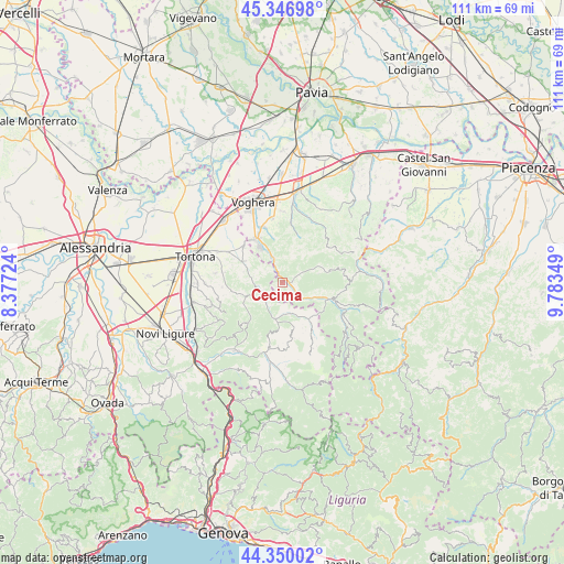
Cecima GPS coordinates[2]
44° 51' 2.376" North, 9° 4' 49.296" East
| Map corner | latitude | longitude |
|---|---|---|
| Upper-left | 45.34698°, | 8.37724° |
| Center: | 44.85066°, | 9.08036° |
| Lower-right: | 44.35002°, | 9.78349° |
| Map W x H: | 110.9×110.8 km | = 68.9×68.8mi |
| max Lat: | 47.04031° ⇑42.9% North |
| Cecima: | 44.85066° |
| min Lat: | ⇓57.1% South 35.50142° |
| min Long | Cecima | max Long |
| 6.69888° | 9.08036° | 18.48682° |
| W 20%⇐ | ⇒80% E |
Elevation
Elevation of Cecima is 340 m = 1115 ft, and this is 33.3 m = 109 ft above average elevation for this country.
| Max E: |
2085 m = 6841 ft | 35.3% |
| Cecima | 340 m 1115 ft | |
| Avg. | 306.7 m = 1006 ft | |
Min E: |
-4 m = -13 ft | 64.7% |
See also: Italy elevation on elevation.city.
Geographical zone
Cecima is located in North temperate zone (between Tropic of Cancer and the Arctic Circle). Distance of this Northern Tropic circle is 2381 km =1479.5 mi to South.| Distance of | km | miles | from Cecima |
|---|---|---|---|
| North Pole | 5020.1 | 3119.3 | to North |
| Arctic Circle | 2414.2 | 1500.1 | to North |
| Tropic Cancer | 2381 | 1479.5 | to South |
| Equator | 4986.9 | 3098.7 | to South |


Nearby cities:
15 places around Cecima: (largest is in red/bold)
• Bagnaria
4.2 km =2.6 mi,  128°
128°
• Brignano
5.1 km =3.2 mi,  218°
218°
• Casa Ponte
7.3 km =4.5 mi,  65°
65°
• Casasco
6.4 km =4 mi,  246°
246°
• Godiasco
5.4 km =3.4 mi,  339°
339°
• Gremiasco
6.4 km =4 mi,  160°
160°
• Momperone
3.9 km =2.4 mi, 249°
• Montemarzino
6.8 km =4.2 mi,  267°
267°
• Montesegale
7.2 km =4.5 mi,  30°
30°
• Ponte Nizza
1.3 km =0.8 mi,  84°
84°
• Pozzol Groppo
5 km =3.1 mi,  307°
307°
• Salice Terme
8.3 km =5.2 mi,  329°
329°
• San Sebastiano Curone
7.3 km =4.5 mi,  189°
189°
• Solaro
8 km =5 mi, 66°
• Susella
7 km =4.3 mi,  10°
10°
Sources, notices
• [Note1] Compared only with cities in Italy existing in our database
• [Src1] Map data: © OpenStreetMap contributors (CC-BY-SA)
• [Src2] Other city data from geonames.org with taken over terms of usage.
• [Src3] Geographical zone / Annual Mean Temperature by Robert A. Rohde @ Wikipedia
