Susella geodata
Susella (Lombardy) is a seat of a third-order administrative division; located in Italy in Europe/Rome (GMT+2) time zone. With population of 2 people, there are 11705 cities with bigger population in this country. Compared to other cities in Italy, 58.1% of cities are located further ↓South; 79.8% of cities are located further →East and 78.5% of cities have lower elevation than Susella. Note1


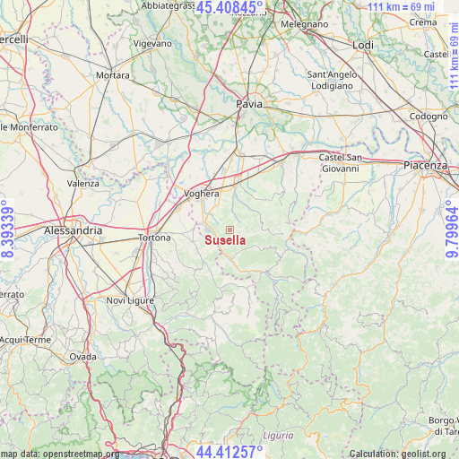
Susella GPS coordinates[2]
44° 54' 45.612" North, 9° 5' 47.436" East
| Map corner | latitude | longitude |
|---|---|---|
| Upper-left | 45.40845°, | 8.39339° |
| Center: | 44.91267°, | 9.09651° |
| Lower-right: | 44.41257°, | 9.79964° |
| Map W x H: | 110.7×110.7 km | = 68.8×68.8mi |
| max Lat: | 47.04031° ⇑41.9% North |
| Susella: | 44.91267° |
| min Lat: | ⇓58.1% South 35.50142° |
| min Long | Susella | max Long |
| 6.69888° | 9.09651° | 18.48682° |
| W 20.2%⇐ | ⇒79.8% E |
Elevation
Elevation of Susella is 500 m = 1640 ft, and this is 193.3 m = 634 ft above average elevation for this country.
| Max E: |
2085 m = 6841 ft | 21.5% |
| Susella | 500 m 1640 ft | |
| Avg. | 306.7 m = 1006 ft | |
Min E: |
-4 m = -13 ft | 78.5% |
See also: Italy elevation on elevation.city.
Geographical zone
Susella is located in North temperate zone (between Tropic of Cancer and the Arctic Circle). Distance of this Northern Tropic circle is 2387.9 km =1483.8 mi to South.| Distance of | km | miles | from Susella |
|---|---|---|---|
| North Pole | 5013.2 | 3115.1 | to North |
| Arctic Circle | 2407.4 | 1495.9 | to North |
| Tropic Cancer | 2387.9 | 1483.8 | to South |
| Equator | 4993.8 | 3103 | to South |


Nearby cities:
15 places around Susella: (largest is in red/bold)
• Borgo Priolo
7.2 km =4.5 mi,  34°
34°
• Borgoratto Mormorolo
7.9 km =4.9 mi,  76°
76°
• Casa Ponte
6.7 km =4.2 mi,  125°
125°
• Cecima
7 km =4.3 mi,  190°
190°
• Codevilla
6.4 km =4 mi,  331°
331°
• Fortunago
7 km =4.3 mi, 81°
• Godiasco
3.6 km =2.2 mi,  240°
240°
• Montesegale
2.4 km =1.5 mi,  105°
105°
• Ponte Nizza
6.8 km =4.2 mi,  179°
179°
• Pozzol Groppo
6.5 km =4 mi,  233°
233°
• Retorbido
6.3 km =3.9 mi,  311°
311°
• Rivanazzano
6.8 km =4.2 mi,  285°
285°
• Salice Terme
5.5 km =3.4 mi,  272°
272°
• Solaro
7.1 km =4.4 mi,  121°
121°
• Torrazza Coste
7.5 km =4.7 mi,  347°
347°
Sources, notices
• [Note1] Compared only with cities in Italy existing in our database
• [Src1] Map data: © OpenStreetMap contributors (CC-BY-SA)
• [Src2] Other city data from geonames.org with taken over terms of usage.
• [Src3] Geographical zone / Annual Mean Temperature by Robert A. Rohde @ Wikipedia
