Maglione geodata
Maglione (Piedmont) is a seat of a third-order administrative division; located in Italy in Europe/Rome (GMT+2) time zone. With population of 429 people, there are 10168 cities with bigger population in this country. Compared to other cities in Italy, 68.7% of cities are located further ↓South; 93.4% of cities are located further →East and 59.1% of cities have lower elevation than Maglione. Note1


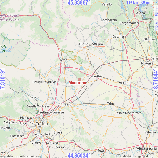
Maglione GPS coordinates[2]
45° 20' 47.976" North, 8° 0' 47.952" East
| Map corner | latitude | longitude |
|---|---|---|
| Upper-left | 45.83867°, | 7.31019° |
| Center: | 45.34666°, | 8.01332° |
| Lower-right: | 44.85034°, | 8.71644° |
| Map W x H: | 109.9×109.9 km | = 68.3×68.3mi |
| max Lat: | 47.04031° ⇑31.3% North |
| Maglione: | 45.34666° |
| min Lat: | ⇓68.7% South 35.50142° |
| min Long | Maglione | max Long |
| 6.69888° | 8.01332° | 18.48682° |
| W 6.6%⇐ | ⇒93.4% E |
Elevation
Elevation of Maglione is 293 m = 961 ft, and this is 13.7 m = 45 ft below average elevation for this country.
| Max E: |
2085 m = 6841 ft | 40.9% |
| Avg. | 306.7 m = 1006 ft | |
| Maglione | 293 m = 961 ft | |
Min E: |
-4 m = -13 ft | 59.1% |
See also: Italy elevation on elevation.city.
Geographical zone
Maglione is located in North temperate zone (between Tropic of Cancer and the Arctic Circle). Distance of this North polar circle is 2359.1 km =1465.9 mi to North.| Distance of | km | miles | from Maglione |
|---|---|---|---|
| North Pole | 4965 | 3085.1 | to North |
| Arctic Circle | 2359.1 | 1465.9 | to North |
| Tropic Cancer | 2436.2 | 1513.8 | to South |
| Equator | 5042.1 | 3133 | to South |


Nearby cities:
15 places around Maglione: (largest is in red/bold)
• Alice Castello
5.3 km =3.3 mi,  62°
62°
• Azeglio
8.6 km =5.3 mi,  348°
348°
• Borgo d'Ale
3 km =1.9 mi,  83°
83°
• Borgomasino
2.6 km =1.6 mi,  310°
310°
• Caravino
7.2 km =4.5 mi,  324°
324°
• Cigliano
4.4 km =2.7 mi,  169°
169°
• Cossano Canavese
4.9 km =3 mi,  339°
339°
• Livorno Ferraris
8.7 km =5.4 mi,  144°
144°
• Mazze
8.1 km =5 mi,  230°
230°
• Moncrivello
2.1 km =1.3 mi,  221°
221°
• Settimo Rottaro
7 km =4.3 mi, 347°
• Tonengo-Casale
8.9 km =5.5 mi, 220°
• Vestignè
6.5 km =4 mi, 313°
• Villareggia
5.1 km =3.2 mi,  213°
213°
• Vische
5.5 km =3.4 mi,  257°
257°
Sources, notices
• [Note1] Compared only with cities in Italy existing in our database
• [Src1] Map data: © OpenStreetMap contributors (CC-BY-SA)
• [Src2] Other city data from geonames.org with taken over terms of usage.
• [Src3] Geographical zone / Annual Mean Temperature by Robert A. Rohde @ Wikipedia
