Villareggia geodata
Villareggia (Piedmont) is a seat of a third-order administrative division; located in Italy in Europe/Rome (GMT+2) time zone. With population of 814 people, there are 7576 cities with bigger population in this country. Compared to other cities in Italy, 67.7% of cities are located further ↓South; 93.8% of cities are located further →East and 55.6% of cities have lower elevation than Villareggia. Note1


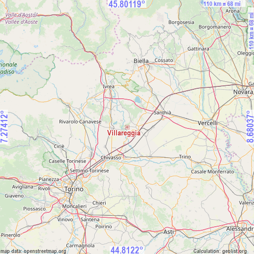
Villareggia GPS coordinates[2]
45° 18' 31.86" North, 7° 58' 38.064" East
| Map corner | latitude | longitude |
|---|---|---|
| Upper-left | 45.80119°, | 7.27412° |
| Center: | 45.30885°, | 7.97724° |
| Lower-right: | 44.8122°, | 8.68037° |
| Map W x H: | 110×110 km | = 68.4×68.4mi |
| max Lat: | 47.04031° ⇑32.3% North |
| Villareggia: | 45.30885° |
| min Lat: | ⇓67.7% South 35.50142° |
| min Long | Villareggia | max Long |
| 6.69888° | 7.97724° | 18.48682° |
| W 6.2%⇐ | ⇒93.8% E |
Elevation
Elevation of Villareggia is 269 m = 883 ft, and this is 37.7 m = 124 ft below average elevation for this country.
| Max E: |
2085 m = 6841 ft | 44.4% |
| Avg. | 306.7 m = 1006 ft | |
| Villareggia | 269 m = 883 ft | |
Min E: |
-4 m = -13 ft | 55.6% |
See also: Italy elevation on elevation.city.
Geographical zone
Villareggia is located in North temperate zone (between Tropic of Cancer and the Arctic Circle). Distance of this North polar circle is 2363.3 km =1468.5 mi to North.| Distance of | km | miles | from Villareggia |
|---|---|---|---|
| North Pole | 4969.2 | 3087.7 | to North |
| Arctic Circle | 2363.3 | 1468.5 | to North |
| Tropic Cancer | 2432 | 1511.2 | to South |
| Equator | 5037.9 | 3130.4 | to South |


Nearby cities:
15 places around Villareggia: (largest is in red/bold)
• Are
7.1 km =4.4 mi,  248°
248°
• Barone Canavese
8.3 km =5.2 mi,  283°
283°
• Borgo d'Ale
7.4 km =4.6 mi,  52°
52°
• Borgomasino
6 km =3.7 mi,  8°
8°
• Caluso
6.8 km =4.2 mi,  266°
266°
• Candia Canavese
7.6 km =4.7 mi,  285°
285°
• Cigliano
3.6 km =2.2 mi,  91°
91°
• Livorno Ferraris
8.4 km =5.2 mi,  110°
110°
• Maglione
5.1 km =3.2 mi,  33°
33°
• Mazze
3.6 km =2.2 mi, 254°
• Moncrivello
3 km =1.9 mi, 28°
• Rondissone
7 km =4.3 mi,  188°
188°
• Sant'Antonino
8.5 km =5.3 mi,  138°
138°
• Tonengo-Casale
3.9 km =2.4 mi,  229°
229°
• Vische
3.9 km =2.4 mi,  319°
319°
Sources, notices
• [Note1] Compared only with cities in Italy existing in our database
• [Src1] Map data: © OpenStreetMap contributors (CC-BY-SA)
• [Src2] Other city data from geonames.org with taken over terms of usage.
• [Src3] Geographical zone / Annual Mean Temperature by Robert A. Rohde @ Wikipedia
