Brondello geodata
Brondello (Piedmont) is a seat of a third-order administrative division; located in Italy in Europe/Rome (GMT+2) time zone. With population of 95 people, there are 11458 cities with bigger population in this country. Compared to other cities in Italy, 52.5% of cities are located further ↓South; 98.3% of cities are located further →East and 75.9% of cities have lower elevation than Brondello. Note1


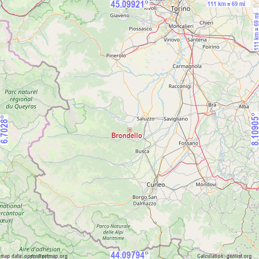
Brondello GPS coordinates[2]
44° 36' 2.628" North, 7° 24' 21.312" East
| Map corner | latitude | longitude |
|---|---|---|
| Upper-left | 45.09921°, | 6.7028° |
| Center: | 44.60073°, | 7.40592° |
| Lower-right: | 44.09794°, | 8.10905° |
| Map W x H: | 111.3×111.3 km | = 69.2×69.2mi |
| max Lat: | 47.04031° ⇑47.5% North |
| Brondello: | 44.60073° |
| min Lat: | ⇓52.5% South 35.50142° |
| min Long | Brondello | max Long |
| 6.69888° | 7.40592° | 18.48682° |
| W 1.7%⇐ | ⇒98.3% E |
Elevation
Elevation of Brondello is 463 m = 1519 ft, and this is 156.3 m = 513 ft above average elevation for this country.
| Max E: |
2085 m = 6841 ft | 24.1% |
| Brondello | 463 m 1519 ft | |
| Avg. | 306.7 m = 1006 ft | |
Min E: |
-4 m = -13 ft | 75.9% |
See also: Italy elevation on elevation.city.
Geographical zone
Brondello is located in North temperate zone (between Tropic of Cancer and the Arctic Circle). Distance of this Northern Tropic circle is 2353.2 km =1462.2 mi to South.| Distance of | km | miles | from Brondello |
|---|---|---|---|
| North Pole | 5047.9 | 3136.6 | to North |
| Arctic Circle | 2442 | 1517.4 | to North |
| Tropic Cancer | 2353.2 | 1462.2 | to South |
| Equator | 4959.1 | 3081.4 | to South |


Nearby cities:
15 places around Brondello: (largest is in red/bold)
• Brossasco
4.9 km =3 mi,  221°
221°
• Castellar
3.4 km =2.1 mi,  47°
47°
• Costiglione Saluzzo
7.5 km =4.7 mi,  122°
122°
• Gambasca
5.7 km =3.5 mi,  304°
304°
• Isasca
2.4 km =1.5 mi,  232°
232°
• Manta
6.6 km =4.1 mi,  75°
75°
• Martiniana Po
4.5 km =2.8 mi,  310°
310°
• Pagno
2 km =1.2 mi, 52°
• Piasco
5.4 km =3.4 mi,  145°
145°
• Revello
6.1 km =3.8 mi,  348°
348°
• Rifreddo
7.3 km =4.5 mi,  319°
319°
• Rossana
6.6 km =4.1 mi,  161°
161°
• Valmala
7.9 km =4.9 mi, 217°
• Venasca
4.4 km =2.7 mi,  189°
189°
• Verzuolo
6.1 km =3.8 mi,  98°
98°
Sources, notices
• [Note1] Compared only with cities in Italy existing in our database
• [Src1] Map data: © OpenStreetMap contributors (CC-BY-SA)
• [Src2] Other city data from geonames.org with taken over terms of usage.
• [Src3] Geographical zone / Annual Mean Temperature by Robert A. Rohde @ Wikipedia
