Musestre geodata
Musestre (Veneto) is a populated place; located in Italy in Europe/Rome (GMT+2) time zone. With population of 1,182 people, there are 6018 cities with bigger population in this country. Compared to other cities in Italy, 76.6% of cities are located further ↓South; 61% of cities are located further ←West and 99% of cities have higher elevation than Musestre. Note1


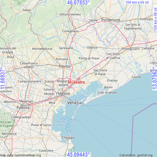
Musestre GPS coordinates[2]
45° 35' 19.104" North, 12° 22' 20.964" East
| Map corner | latitude | longitude |
|---|---|---|
| Upper-left | 46.07853°, | 11.66937° |
| Center: | 45.58864°, | 12.37249° |
| Lower-right: | 45.09443°, | 13.07562° |
| Map W x H: | 109.4×109.4 km | = 68×68mi |
| max Lat: | 47.04031° ⇑23.4% North |
| Musestre: | 45.58864° |
| min Lat: | ⇓76.6% South 35.50142° |
| min Long | Musestre | max Long |
| 6.69888° | 12.37249° | 18.48682° |
| W 61%⇐ | ⇒39% E |
Elevation
Elevation of Musestre is 2 m = 7 ft, and this is 304.7 m = 1000 ft below average elevation for this country.
| Max E: |
2085 m = 6841 ft | 99% |
| Avg. | 306.7 m = 1006 ft | |
| Musestre | 2 m = 7 ft | |
Min E: |
-4 m = -13 ft | 1% |
See also: Italy elevation on elevation.city.
Geographical zone
Musestre is located in North temperate zone (between Tropic of Cancer and the Arctic Circle). Distance of this North polar circle is 2332.2 km =1449.2 mi to North.| Distance of | km | miles | from Musestre |
|---|---|---|---|
| North Pole | 4938.1 | 3068.4 | to North |
| Arctic Circle | 2332.2 | 1449.2 | to North |
| Tropic Cancer | 2463.1 | 1530.5 | to South |
| Equator | 5069 | 3149.7 | to South |


Nearby cities:
15 places around Musestre: (largest is in red/bold)
• Biancade
6.8 km =4.2 mi,  350°
350°
• Bonisiolo
4.3 km =2.7 mi,  260°
260°
• Ca' Corner
5.8 km =3.6 mi,  124°
124°
• Casale sul Sile
3.7 km =2.3 mi,  283°
283°
• Cendon
6.6 km =4.1 mi,  326°
326°
• Conscio
7.7 km =4.8 mi,  294°
294°
• Lughignano
5.5 km =3.4 mi,  317°
317°
• Marcon-Gaggio-Colmello
6.3 km =3.9 mi,  244°
244°
• Meolo
7.1 km =4.4 mi,  60°
60°
• Monastier di Treviso
8.4 km =5.2 mi,  24°
24°
• Quarto d'Altino
1 km =0.6 mi,  176°
176°
• Roncade
3.7 km =2.3 mi,  4°
4°
• San Liberale
5.1 km =3.2 mi,  208°
208°
• Sant'Elena
5 km =3.1 mi, 324°
• Zerman
8.2 km =5.1 mi, 261°
Sources, notices
• [Note1] Compared only with cities in Italy existing in our database
• [Src1] Map data: © OpenStreetMap contributors (CC-BY-SA)
• [Src2] Other city data from geonames.org with taken over terms of usage.
• [Src3] Geographical zone / Annual Mean Temperature by Robert A. Rohde @ Wikipedia
