Biancade geodata
Biancade (Veneto) is a populated place; located in Italy in Europe/Rome (GMT+2) time zone. With population of 2,654 people, there are 3366 cities with bigger population in this country. Compared to other cities in Italy, 79% of cities are located further ↓South; 60.8% of cities are located further ←West and 95.9% of cities have higher elevation than Biancade. Note1


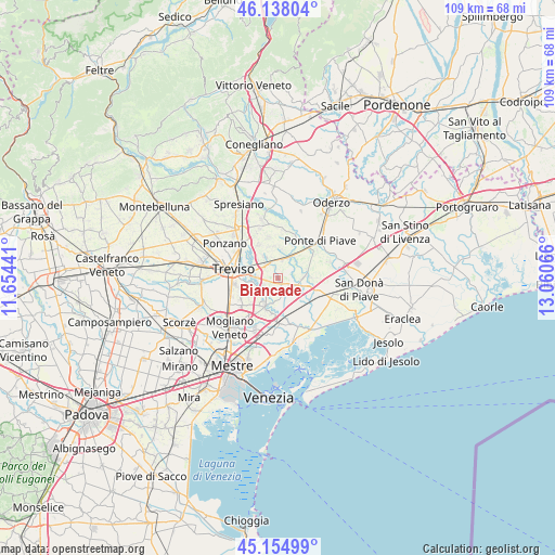
Biancade GPS coordinates[2]
45° 38' 55.212" North, 12° 21' 27.108" East
| Map corner | latitude | longitude |
|---|---|---|
| Upper-left | 46.13804°, | 11.65441° |
| Center: | 45.64867°, | 12.35753° |
| Lower-right: | 45.15499°, | 13.06066° |
| Map W x H: | 109.3×109.3 km | = 67.9×67.9mi |
| max Lat: | 47.04031° ⇑21% North |
| Biancade: | 45.64867° |
| min Lat: | ⇓79% South 35.50142° |
| min Long | Biancade | max Long |
| 6.69888° | 12.35753° | 18.48682° |
| W 60.8%⇐ | ⇒39.2% E |
Elevation
Elevation of Biancade is 7 m = 23 ft, and this is 299.7 m = 983 ft below average elevation for this country.
| Max E: |
2085 m = 6841 ft | 95.9% |
| Avg. | 306.7 m = 1006 ft | |
| Biancade | 7 m = 23 ft | |
Min E: |
-4 m = -13 ft | 4.1% |
See also: Italy elevation on elevation.city.
Geographical zone
Biancade is located in North temperate zone (between Tropic of Cancer and the Arctic Circle). Distance of this North polar circle is 2325.5 km =1445 mi to North.| Distance of | km | miles | from Biancade |
|---|---|---|---|
| North Pole | 4931.4 | 3064.2 | to North |
| Arctic Circle | 2325.5 | 1445 | to North |
| Tropic Cancer | 2469.7 | 1534.6 | to South |
| Equator | 5075.7 | 3153.9 | to South |


Nearby cities:
15 places around Biancade: (largest is in red/bold)
• Casale sul Sile
6.3 km =3.9 mi,  202°
202°
• Casier
5 km =3.1 mi,  261°
261°
• Cavrie
6.2 km =3.9 mi,  8°
8°
• Cendon
2.8 km =1.7 mi,  244°
244°
• Fornaci
6.2 km =3.9 mi,  86°
86°
• Lughignano
3.6 km =2.2 mi,  224°
224°
• Mignagola
5.3 km =3.3 mi,  327°
327°
• Monastier di Treviso
4.8 km =3 mi,  77°
77°
• Pero
6.5 km =4 mi,  353°
353°
• Roncade
3.3 km =2.1 mi,  153°
153°
• Rovarè
4.9 km =3 mi,  47°
47°
• San Biagio di Callalta
4.2 km =2.6 mi,  21°
21°
• San Floriano-Olmi
3.5 km =2.2 mi,  322°
322°
• Sant'Elena
3.1 km =1.9 mi,  214°
214°
• Silea
4.7 km =2.9 mi,  277°
277°
Sources, notices
• [Note1] Compared only with cities in Italy existing in our database
• [Src1] Map data: © OpenStreetMap contributors (CC-BY-SA)
• [Src2] Other city data from geonames.org with taken over terms of usage.
• [Src3] Geographical zone / Annual Mean Temperature by Robert A. Rohde @ Wikipedia
