Margine Coperta-Traversagna geodata
Margine Coperta-Traversagna (Tuscany) is a populated place; located in Italy in Europe/Rome (GMT+2) time zone. With population of 6,690 people, there are 1472 cities with bigger population in this country. Compared to other cities in Italy, 56% of cities are located further ↑North; 60.2% of cities are located further →East and 88.3% of cities have higher elevation than Margine Coperta-Traversagna. Note1
Current local time in Margine Coperta-Traversagna:
07:51 PM, WednesdayDifference from your time zone: hours


Margine Coperta-Traversagna GPS coordinates[2]
43° 52' 47.172" North, 10° 45' 26.388" East
| Map corner | latitude | longitude |
|---|---|---|
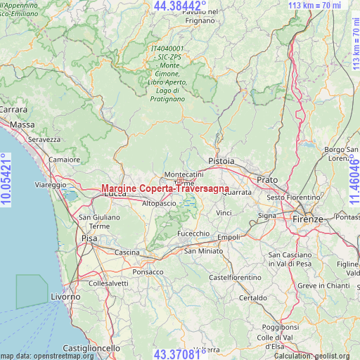
| Upper-left | 44.38442°, | 10.05421° |
| Center: | 43.87977°, | 10.75733° |
| Lower-right: | 43.37081°, | 11.46046° |
| Map W x H: | 112.7×112.7 km | = 70×70mi |
| max Lat: | 47.04031° ⇑56% North |
| Margine Coperta-Traversagna: | 43.87977° |
| min Lat: | ⇓44% South 35.50142° |
| min Long | Margine Coperta | max Long |
| 6.69888° | 10.75733° | 18.48682° |
| W 39.8%⇐ | ⇒60.2% E |
Elevation
Elevation of Margine Coperta-Traversagna is 22 m = 72 ft, and this is 284.7 m = 934 ft below average elevation for this country.
| Max E: |
2085 m = 6841 ft | 88.3% |
| Avg. | 306.7 m = 1006 ft | |
| Margine Coperta-Traversagna | 22 m = 72 ft | |
Min E: |
-4 m = -13 ft | 11.7% |
See also: Italy elevation on elevation.city.
Geographical zone
Margine Coperta-Traversagna is located in North temperate zone (between Tropic of Cancer and the Arctic Circle). Distance of this Northern Tropic circle is 2273.1 km =1412.4 mi to South.| Distance of | km | miles | from Margine Coperta-Traversagna |
|---|---|---|---|
| North Pole | 5128.1 | 3186.5 | to North |
| Arctic Circle | 2522.2 | 1567.2 | to North |
| Tropic Cancer | 2273.1 | 1412.4 | to South |
| Equator | 4879 | 3031.7 | to South |


Nearby cities:
15 places around Margine Coperta-Traversagna: (largest is in red/bold)
• Anchione
6 km =3.7 mi,  179°
179°
• Borgo a Buggiano
1.9 km =1.2 mi,  254°
254°
• Chiesina Uzzanese
5.4 km =3.4 mi,  213°
213°
• Forone
3.5 km =2.2 mi,  241°
241°
• Marliana
6.1 km =3.8 mi,  9°
9°
• Massa
3.4 km =2.1 mi,  342°
342°
• Monsummano Terme
4.7 km =2.9 mi,  107°
107°
• Montecatini-Terme
1.2 km =0.7 mi,  80°
80°
• Pescia
5.6 km =3.5 mi,  278°
278°
• Pieve a Nievole
3.4 km =2.1 mi,  87°
87°
• Ponte Buggianese
3.8 km =2.4 mi,  191°
191°
• Ponte di Serravalle
5.5 km =3.4 mi,  70°
70°
• San Salvatore
6.5 km =4 mi, 241°
• Santa Lucia
4.4 km =2.7 mi,  274°
274°
• Uzzano
4.7 km =2.9 mi,  294°
294°
Sources, notices
• [Note1] Compared only with cities in Italy existing in our database
• [Src1] Map data: © OpenStreetMap contributors (CC-BY-SA)
• [Src2] Other city data from geonames.org with taken over terms of usage.
• [Src3] Geographical zone / Annual Mean Temperature by Robert A. Rohde @ Wikipedia
