Pescia geodata
Pescia (Tuscany) is a seat of a third-order administrative division; located in Italy in Europe/Rome (GMT+2) time zone. With population of 11,567 people, there are 808 cities with bigger population in this country. Compared to other cities in Italy, 55.9% of cities are located further ↑North; 61.1% of cities are located further →East and 82% of cities have higher elevation than Pescia. Note1


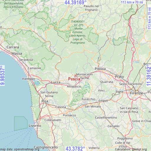
Pescia GPS coordinates[2]
43° 53' 13.56" North, 10° 41' 18.564" East
| Map corner | latitude | longitude |
|---|---|---|
| Upper-left | 44.39169°, | 9.98537° |
| Center: | 43.8871°, | 10.68849° |
| Lower-right: | 43.3782°, | 11.39162° |
| Map W x H: | 112.7×112.7 km | = 70×70mi |
| max Lat: | 47.04031° ⇑55.9% North |
| Pescia: | 43.8871° |
| min Lat: | ⇓44.1% South 35.50142° |
| min Long | Pescia | max Long |
| 6.69888° | 10.68849° | 18.48682° |
| W 38.9%⇐ | ⇒61.1% E |
Elevation
Elevation of Pescia is 42 m = 138 ft, and this is 264.7 m = 868 ft below average elevation for this country.
| Max E: |
2085 m = 6841 ft | 82% |
| Avg. | 306.7 m = 1006 ft | |
| Pescia | 42 m = 138 ft | |
Min E: |
-4 m = -13 ft | 18% |
See also: Italy elevation on elevation.city.
Geographical zone
Pescia is located in North temperate zone (between Tropic of Cancer and the Arctic Circle). Distance of this Northern Tropic circle is 2273.9 km =1412.9 mi to South.| Distance of | km | miles | from Pescia |
|---|---|---|---|
| North Pole | 5127.3 | 3186 | to North |
| Arctic Circle | 2521.4 | 1566.7 | to North |
| Tropic Cancer | 2273.9 | 1412.9 | to South |
| Equator | 4879.8 | 3032.2 | to South |


Nearby cities:
15 places around Pescia: (largest is in red/bold)
• Altopascio
7.9 km =4.9 mi,  186°
186°
• Borgo a Buggiano
3.9 km =2.4 mi,  109°
109°
• Chiesina Uzzanese
5.9 km =3.7 mi,  154°
154°
• Forone
3.5 km =2.2 mi,  134°
134°
• Margine Coperta-Traversagna
5.6 km =3.5 mi,  98°
98°
• Marginone
5.5 km =3.4 mi,  177°
177°
• Massa
5.1 km =3.2 mi,  61°
61°
• Montecarlo
4.2 km =2.6 mi,  203°
203°
• Montecatini-Terme
6.7 km =4.2 mi, 95°
• Ponte Buggianese
6.6 km =4.1 mi, 133°
• Porcari
7.7 km =4.8 mi,  228°
228°
• San Salvatore
3.9 km =2.4 mi, 183°
• Santa Lucia
1.3 km =0.8 mi, 111°
• Uzzano
1.7 km =1.1 mi,  47°
47°
• Villa Basilica
5.5 km =3.4 mi,  321°
321°
Sources, notices
• [Note1] Compared only with cities in Italy existing in our database
• [Src1] Map data: © OpenStreetMap contributors (CC-BY-SA)
• [Src2] Other city data from geonames.org with taken over terms of usage.
• [Src3] Geographical zone / Annual Mean Temperature by Robert A. Rohde @ Wikipedia
