Nibbia geodata
Nibbia (Piedmont) is a section of populated place; located in Italy in Europe/Rome (GMT+2) time zone. With population of 572 people, there are 9247 cities with bigger population in this country. Compared to other cities in Italy, 73.2% of cities are located further ↓South; 87.3% of cities are located further →East and 59.6% of cities have higher elevation than Nibbia. Note1
Administrative division(s):
- Level 1: Piedmont
- Level 2: Provincia di Novara
- Level 3: San Pietro Mosezzo


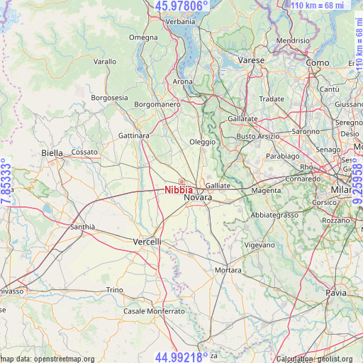
Nibbia GPS coordinates[2]
45° 29' 14.208" North, 8° 33' 23.256" East
| Map corner | latitude | longitude |
|---|---|---|
| Upper-left | 45.97806°, | 7.85333° |
| Center: | 45.48728°, | 8.55646° |
| Lower-right: | 44.99218°, | 9.25958° |
| Map W x H: | 109.6×109.6 km | = 68.1×68.1mi |
| max Lat: | 47.04031° ⇑26.8% North |
| Nibbia: | 45.48728° |
| min Lat: | ⇓73.2% South 35.50142° |
| min Long | Nibbia | max Long |
| 6.69888° | 8.55646° | 18.48682° |
| W 12.7%⇐ | ⇒87.3% E |
Elevation
Elevation of Nibbia is 166 m = 545 ft, and this is 140.7 m = 462 ft below average elevation for this country.
| Max E: |
2085 m = 6841 ft | 59.6% |
| Avg. | 306.7 m = 1006 ft | |
| Nibbia | 166 m = 545 ft | |
Min E: |
-4 m = -13 ft | 40.4% |
See also: Italy elevation on elevation.city.
Geographical zone
Nibbia is located in North temperate zone (between Tropic of Cancer and the Arctic Circle). Distance of this North polar circle is 2343.5 km =1456.2 mi to North.| Distance of | km | miles | from Nibbia |
|---|---|---|---|
| North Pole | 4949.4 | 3075.4 | to North |
| Arctic Circle | 2343.5 | 1456.2 | to North |
| Tropic Cancer | 2451.8 | 1523.5 | to South |
| Equator | 5057.7 | 3142.7 | to South |


Nearby cities:
15 places around Nibbia: (largest is in red/bold)
• Biandrate
8.2 km =5.1 mi,  241°
241°
• Briona
8.6 km =5.3 mi,  315°
315°
• Caltignaga
4.4 km =2.7 mi,  31°
31°
• Cameri
8.4 km =5.2 mi,  79°
79°
• Casalbeltrame
8.9 km =5.5 mi,  232°
232°
• Casaleggio Novara
4.9 km =3 mi,  270°
270°
• Castellazzo Novarese
6.1 km =3.8 mi,  298°
298°
• Lumellogno
9.1 km =5.7 mi,  164°
164°
• Mandello Vitta
7.6 km =4.7 mi,  277°
277°
• Novara
6.8 km =4.2 mi,  131°
131°
• San Pietro Mosezzo
3.8 km =2.4 mi,  194°
194°
• Sillavengo
9.7 km =6 mi,  292°
292°
• Sologno
5.7 km =3.5 mi,  13°
13°
• Torrion Quartara
8.9 km =5.5 mi,  149°
149°
• Vicolungo
7.5 km =4.7 mi,  259°
259°
Sources, notices
• [Note1] Compared only with cities in Italy existing in our database
• [Src1] Map data: © OpenStreetMap contributors (CC-BY-SA)
• [Src2] Other city data from geonames.org with taken over terms of usage.
• [Src3] Geographical zone / Annual Mean Temperature by Robert A. Rohde @ Wikipedia
