Fabbrica geodata
Fabbrica (Tuscany) is a populated place; located in Italy in Europe/Rome (GMT+2) time zone. With population of 735 people, there are 8051 cities with bigger population in this country. Compared to other cities in Italy, 59.7% of cities are located further ↑North; 60.2% of cities are located further →East and 59.4% of cities have higher elevation than Fabbrica. Note1


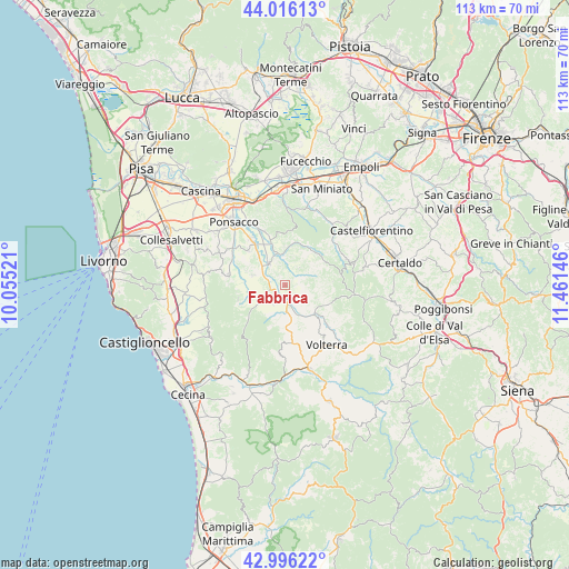
Fabbrica GPS coordinates[2]
43° 30' 29.988" North, 10° 45' 29.988" East
| Map corner | latitude | longitude |
|---|---|---|
| Upper-left | 44.01613°, | 10.05521° |
| Center: | 43.50833°, | 10.75833° |
| Lower-right: | 42.99622°, | 11.46146° |
| Map W x H: | 113.4×113.4 km | = 70.5×70.5mi |
| max Lat: | 47.04031° ⇑59.7% North |
| Fabbrica: | 43.50833° |
| min Lat: | ⇓40.3% South 35.50142° |
| min Long | Fabbrica | max Long |
| 6.69888° | 10.75833° | 18.48682° |
| W 39.8%⇐ | ⇒60.2% E |
Elevation
Elevation of Fabbrica is 168 m = 551 ft, and this is 138.7 m = 455 ft below average elevation for this country.
| Max E: |
2085 m = 6841 ft | 59.4% |
| Avg. | 306.7 m = 1006 ft | |
| Fabbrica | 168 m = 551 ft | |
Min E: |
-4 m = -13 ft | 40.6% |
See also: Italy elevation on elevation.city.
Geographical zone
Fabbrica is located in North temperate zone (between Tropic of Cancer and the Arctic Circle). Distance of this Northern Tropic circle is 2231.8 km =1386.8 mi to South.| Distance of | km | miles | from Fabbrica |
|---|---|---|---|
| North Pole | 5169.4 | 3212.1 | to North |
| Arctic Circle | 2563.5 | 1592.9 | to North |
| Tropic Cancer | 2231.8 | 1386.8 | to South |
| Equator | 4837.7 | 3006 | to South |


Nearby cities:
15 places around Fabbrica: (largest is in red/bold)
• Capannoli
11.2 km =7 mi,  322°
322°
• Casciana Terme
11.5 km =7.1 mi,  280°
280°
• Chianni
9.9 km =6.2 mi,  252°
252°
• Forcoli
11.4 km =7.1 mi,  338°
338°
• Lajatico
4.5 km =2.8 mi,  212°
212°
• Lari
14.9 km =9.3 mi,  295°
295°
• Montaione
13.4 km =8.3 mi,  69°
69°
• Montecatini Val di Cecina
12.9 km =8 mi,  183°
183°
• Palaia
10.9 km =6.8 mi,  5°
5°
• Peccioli
5.7 km =3.5 mi, 324°
• San Pietro Belvedere
10.1 km =6.3 mi,  312°
312°
• Selvatelle
8.1 km =5 mi, 318°
• Terricciola
6.6 km =4.1 mi,  286°
286°
• Treggiaia
14.5 km =9 mi,  331°
331°
• Volterra
14.4 km =8.9 mi,  144°
144°
Sources, notices
• [Note1] Compared only with cities in Italy existing in our database
• [Src1] Map data: © OpenStreetMap contributors (CC-BY-SA)
• [Src2] Other city data from geonames.org with taken over terms of usage.
• [Src3] Geographical zone / Annual Mean Temperature by Robert A. Rohde @ Wikipedia
