Terricciola geodata
Terricciola (Tuscany) is a seat of a third-order administrative division; located in Italy in Europe/Rome (GMT+2) time zone. With population of 1,035 people, there are 6527 cities with bigger population in this country. Compared to other cities in Italy, 59.6% of cities are located further ↑North; 61.1% of cities are located further →East and 57.7% of cities have higher elevation than Terricciola. Note1


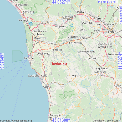
Terricciola GPS coordinates[2]
43° 31' 30.18" North, 10° 40' 46.596" East
| Map corner | latitude | longitude |
|---|---|---|
| Upper-left | 44.03271°, | 9.97649° |
| Center: | 43.52505°, | 10.67961° |
| Lower-right: | 43.01308°, | 11.38274° |
| Map W x H: | 113.4×113.4 km | = 70.5×70.5mi |
| max Lat: | 47.04031° ⇑59.6% North |
| Terricciola: | 43.52505° |
| min Lat: | ⇓40.4% South 35.50142° |
| min Long | Terricciola | max Long |
| 6.69888° | 10.67961° | 18.48682° |
| W 38.9%⇐ | ⇒61.1% E |
Elevation
Elevation of Terricciola is 182 m = 597 ft, and this is 124.7 m = 409 ft below average elevation for this country.
| Max E: |
2085 m = 6841 ft | 57.7% |
| Avg. | 306.7 m = 1006 ft | |
| Terricciola | 182 m = 597 ft | |
Min E: |
-4 m = -13 ft | 42.3% |
See also: Italy elevation on elevation.city.
Geographical zone
Terricciola is located in North temperate zone (between Tropic of Cancer and the Arctic Circle). Distance of this Northern Tropic circle is 2233.6 km =1387.9 mi to South.| Distance of | km | miles | from Terricciola |
|---|---|---|---|
| North Pole | 5167.5 | 3210.9 | to North |
| Arctic Circle | 2561.6 | 1591.7 | to North |
| Tropic Cancer | 2233.6 | 1387.9 | to South |
| Equator | 4839.5 | 3007.1 | to South |


Nearby cities:
15 places around Terricciola: (largest is in red/bold)
• Capannoli
7.1 km =4.4 mi,  355°
355°
• Casciana Terme
5 km =3.1 mi,  272°
272°
• Chianni
5.7 km =3.5 mi,  212°
212°
• Crespina
10.7 km =6.6 mi,  299°
299°
• Fabbrica
6.6 km =4.1 mi,  106°
106°
• Forcoli
9 km =5.6 mi,  13°
13°
• Lajatico
6.9 km =4.3 mi,  144°
144°
• Lari
8.4 km =5.2 mi, 302°
• Le Casine-Perignano-Spinelli
11.4 km =7.1 mi,  317°
317°
• Palaia
11.6 km =7.2 mi,  39°
39°
• Peccioli
4.1 km =2.5 mi,  47°
47°
• San Pietro Belvedere
5.1 km =3.2 mi,  347°
347°
• Santa Luce
11.2 km =7 mi,  237°
237°
• Selvatelle
4.3 km =2.7 mi, 12°
• Treggiaia
10.9 km =6.8 mi, 357°
Sources, notices
• [Note1] Compared only with cities in Italy existing in our database
• [Src1] Map data: © OpenStreetMap contributors (CC-BY-SA)
• [Src2] Other city data from geonames.org with taken over terms of usage.
• [Src3] Geographical zone / Annual Mean Temperature by Robert A. Rohde @ Wikipedia
