Mercatale-San Quirico geodata
Mercatale-San Quirico (Tuscany) is a seat of a third-order administrative division; located in Italy in Europe/Rome (GMT+2) time zone. With population of 3,910 people, there are 2447 cities with bigger population in this country. Compared to other cities in Italy, 54.3% of cities are located further ↑North; 55.1% of cities are located further →East and 53.2% of cities have lower elevation than Mercatale-San Quirico. Note1
Current local time in Mercatale-San Quirico:
09:02 PM, WednesdayDifference from your time zone: hours


Mercatale-San Quirico GPS coordinates[2]
44° 2' 39.336" North, 11° 9' 5.868" East
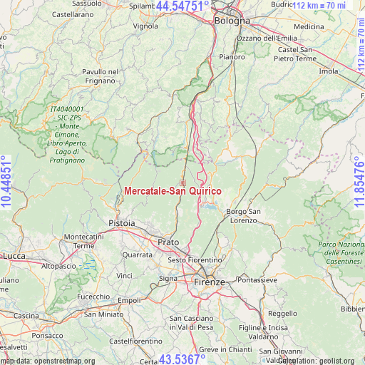
| Map corner | latitude | longitude |
|---|---|---|
| Upper-left | 44.54751°, | 10.44851° |
| Center: | 44.04426°, | 11.15163° |
| Lower-right: | 43.5367°, | 11.85476° |
| Map W x H: | 112.4×112.4 km | = 69.8×69.8mi |
| max Lat: | 47.04031° ⇑54.3% North |
| Mercatale-San Quirico: | 44.04426° |
| min Lat: | ⇓45.7% South 35.50142° |
| min Long | Mercatale-San Q | max Long |
| 6.69888° | 11.15163° | 18.48682° |
| W 44.9%⇐ | ⇒55.1% E |
Elevation
Elevation of Mercatale-San Quirico is 254 m = 833 ft, and this is 52.7 m = 173 ft below average elevation for this country.
| Max E: |
2085 m = 6841 ft | 46.8% |
| Avg. | 306.7 m = 1006 ft | |
| Mercatale-San Quirico | 254 m = 833 ft | |
Min E: |
-4 m = -13 ft | 53.2% |
See also: Italy elevation on elevation.city.
Geographical zone
Mercatale-San Quirico is located in North temperate zone (between Tropic of Cancer and the Arctic Circle). Distance of this Northern Tropic circle is 2291.3 km =1423.7 mi to South.| Distance of | km | miles | from Mercatale-San Quirico |
|---|---|---|---|
| North Pole | 5109.8 | 3175.1 | to North |
| Arctic Circle | 2503.9 | 1555.9 | to North |
| Tropic Cancer | 2291.3 | 1423.7 | to South |
| Equator | 4897.3 | 3043 | to South |


Nearby cities:
15 places around Mercatale-San Quirico: (largest is in red/bold)
• Baragazza
10.1 km =6.3 mi,  22°
22°
• Barberino di Mugello
8.4 km =5.2 mi,  126°
126°
• Cantagallo
6.3 km =3.9 mi,  246°
246°
• Carmignanello
5 km =3.1 mi,  190°
190°
• Castiglione dei Pepoli
11 km =6.8 mi,  3°
3°
• Cavallina
9.3 km =5.8 mi,  136°
136°
• Fognano
13.8 km =8.6 mi,  222°
222°
• Galliano
11.7 km =7.3 mi,  104°
104°
• Il Fabbro
7.5 km =4.7 mi,  196°
196°
• Montepiano
5.2 km =3.2 mi,  7°
7°
• Schignano
9.6 km =6 mi, 202°
• Terrigoli
2 km =1.2 mi, 194°
• Tobbiana
12.5 km =7.8 mi, 224°
• Vaiano
8.8 km =5.5 mi, 194°
• Vernio
0.4 km =0.2 mi,  346°
346°
Sources, notices
• [Note1] Compared only with cities in Italy existing in our database
• [Src1] Map data: © OpenStreetMap contributors (CC-BY-SA)
• [Src2] Other city data from geonames.org with taken over terms of usage.
• [Src3] Geographical zone / Annual Mean Temperature by Robert A. Rohde @ Wikipedia
