Cantagallo geodata
Cantagallo (Tuscany) is a seat of a third-order administrative division; located in Italy in Europe/Rome (GMT+2) time zone. With population of 60 people, there are 11570 cities with bigger population in this country. Compared to other cities in Italy, 54.5% of cities are located further ↑North; 56.2% of cities are located further →East and 82.3% of cities have lower elevation than Cantagallo. Note1


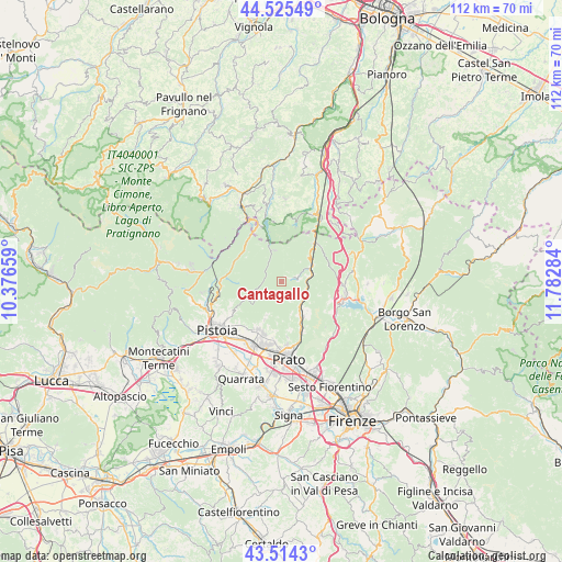
Cantagallo GPS coordinates[2]
44° 1' 19.38" North, 11° 4' 46.956" East
| Map corner | latitude | longitude |
|---|---|---|
| Upper-left | 44.52549°, | 10.37659° |
| Center: | 44.02205°, | 11.07971° |
| Lower-right: | 43.5143°, | 11.78284° |
| Map W x H: | 112.4×112.4 km | = 69.8×69.8mi |
| max Lat: | 47.04031° ⇑54.5% North |
| Cantagallo: | 44.02205° |
| min Lat: | ⇓45.5% South 35.50142° |
| min Long | Cantagallo | max Long |
| 6.69888° | 11.07971° | 18.48682° |
| W 43.8%⇐ | ⇒56.2% E |
Elevation
Elevation of Cantagallo is 560 m = 1837 ft, and this is 253.3 m = 831 ft above average elevation for this country.
| Max E: |
2085 m = 6841 ft | 17.7% |
| Cantagallo | 560 m 1837 ft | |
| Avg. | 306.7 m = 1006 ft | |
Min E: |
-4 m = -13 ft | 82.3% |
See also: Italy elevation on elevation.city.
Geographical zone
Cantagallo is located in North temperate zone (between Tropic of Cancer and the Arctic Circle). Distance of this Northern Tropic circle is 2288.9 km =1422.3 mi to South.| Distance of | km | miles | from Cantagallo |
|---|---|---|---|
| North Pole | 5112.3 | 3176.6 | to North |
| Arctic Circle | 2506.4 | 1557.4 | to North |
| Tropic Cancer | 2288.9 | 1422.3 | to South |
| Equator | 4894.8 | 3041.5 | to South |


Nearby cities:
15 places around Cantagallo: (largest is in red/bold)
• Carmignanello
5.4 km =3.4 mi,  116°
116°
• Fognano
8.5 km =5.3 mi,  204°
204°
• Fornacelle
11.5 km =7.1 mi, 198°
• Il Fabbro
6 km =3.7 mi,  142°
142°
• Mercatale-San Quirico
6.3 km =3.9 mi,  66°
66°
• Montale
10.9 km =6.8 mi,  207°
207°
• Montemurlo
11.1 km =6.9 mi, 197°
• Montepiano
10 km =6.2 mi,  40°
40°
• Ponzano
11.2 km =7 mi,  235°
235°
• Sambuca Pistoiese
11.2 km =7 mi,  325°
325°
• Schignano
6.7 km =4.2 mi,  161°
161°
• Terrigoli
5.3 km =3.3 mi,  84°
84°
• Tobbiana
7.2 km =4.5 mi, 204°
• Vaiano
7 km =4.3 mi,  149°
149°
• Vernio
6.3 km =3.9 mi,  63°
63°
Sources, notices
• [Note1] Compared only with cities in Italy existing in our database
• [Src1] Map data: © OpenStreetMap contributors (CC-BY-SA)
• [Src2] Other city data from geonames.org with taken over terms of usage.
• [Src3] Geographical zone / Annual Mean Temperature by Robert A. Rohde @ Wikipedia
