Gallo-Tre Re-Mezzana Corti geodata
Gallo-Tre Re-Mezzana Corti (Lombardy) is a populated place; located in Italy in Europe/Rome (GMT+2) time zone. With population of 2,563 people, there are 3448 cities with bigger population in this country. Compared to other cities in Italy, 63.1% of cities are located further ↓South; 79.3% of cities are located further →East and 77.5% of cities have higher elevation than Gallo-Tre Re-Mezzana Corti. Note1
Current local time in Gallo-Tre Re-Mezzana Corti:
12:57 AM, ThursdayDifference from your time zone: hours


Gallo-Tre Re-Mezzana Corti GPS coordinates[2]
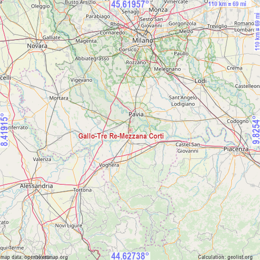
45° 7' 32.268" North, 9° 7' 20.172" East
| Map corner | latitude | longitude |
|---|---|---|
| Upper-left | 45.61957°, | 8.41915° |
| Center: | 45.12563°, | 9.12227° |
| Lower-right: | 44.62738°, | 9.8254° |
| Map W x H: | 110.3×110.3 km | = 68.5×68.5mi |
| max Lat: | 47.04031° ⇑36.9% North |
| Gallo-Tre Re-Mezzana Corti: | 45.12563° |
| min Lat: | ⇓63.1% South 35.50142° |
| min Long | Gallo-Tre Re-Me | max Long |
| 6.69888° | 9.12227° | 18.48682° |
| W 20.7%⇐ | ⇒79.3% E |
Elevation
Elevation of Gallo-Tre Re-Mezzana Corti is 62 m = 203 ft, and this is 244.7 m = 803 ft below average elevation for this country.
| Max E: |
2085 m = 6841 ft | 77.5% |
| Avg. | 306.7 m = 1006 ft | |
| Gallo-Tre Re-Mezzana Corti | 62 m = 203 ft | |
Min E: |
-4 m = -13 ft | 22.5% |
See also: Italy elevation on elevation.city.
Geographical zone
Gallo-Tre Re-Mezzana Corti is located in North temperate zone (between Tropic of Cancer and the Arctic Circle). Distance of this North polar circle is 2383.7 km =1481.2 mi to North.| Distance of | km | miles | from Gallo-Tre Re-Mezzana Corti |
|---|---|---|---|
| North Pole | 4989.6 | 3100.4 | to North |
| Arctic Circle | 2383.7 | 1481.2 | to North |
| Tropic Cancer | 2411.6 | 1498.5 | to South |
| Equator | 5017.5 | 3117.7 | to South |


Nearby cities:
15 places around Gallo-Tre Re-Mezzana Corti: (largest is in red/bold)
• Bastida Pancarana
5.3 km =3.3 mi,  213°
213°
• Bivio Cava Manara
1.8 km =1.1 mi,  356°
356°
• Bressana
5.3 km =3.3 mi,  172°
172°
• Carbonara al Ticino
6.2 km =3.9 mi,  313°
313°
• Castelletto Po
6.5 km =4 mi,  195°
195°
• Cava Manara
2 km =1.2 mi,  324°
324°
• Madonna
3 km =1.9 mi,  4°
4°
• Mezzanino
6.5 km =4 mi,  90°
90°
• Rea
2.9 km =1.8 mi,  118°
118°
• Rotta
4.5 km =2.8 mi,  24°
24°
• Sairano
5.7 km =3.5 mi,  282°
282°
• San Martino Siccomario
4.4 km =2.7 mi, 18°
• Sommo
2.9 km =1.8 mi,  286°
286°
• Travacò Siccomario
3.9 km =2.4 mi,  48°
48°
• Verrua Po
4.7 km =2.9 mi, 116°
Sources, notices
• [Note1] Compared only with cities in Italy existing in our database
• [Src1] Map data: © OpenStreetMap contributors (CC-BY-SA)
• [Src2] Other city data from geonames.org with taken over terms of usage.
• [Src3] Geographical zone / Annual Mean Temperature by Robert A. Rohde @ Wikipedia
