Lucino geodata
Lucino (Lombardy) is a seat of a third-order administrative division; located in Italy in Europe/Rome (GMT+2) time zone. With population of 2,441 people, there are 3597 cities with bigger population in this country. Compared to other cities in Italy, 85% of cities are located further ↓South; 80.6% of cities are located further →East and 61.6% of cities have lower elevation than Lucino. Note1


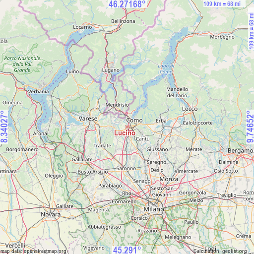
Lucino GPS coordinates[2]
45° 47' 0.6" North, 9° 2' 36.24" East
| Map corner | latitude | longitude |
|---|---|---|
| Upper-left | 46.27168°, | 8.34027° |
| Center: | 45.7835°, | 9.0434° |
| Lower-right: | 45.291°, | 9.74652° |
| Map W x H: | 109×109 km | = 67.7×67.7mi |
| max Lat: | 47.04031° ⇑15% North |
| Lucino: | 45.7835° |
| min Lat: | ⇓85% South 35.50142° |
| min Long | Lucino | max Long |
| 6.69888° | 9.0434° | 18.48682° |
| W 19.4%⇐ | ⇒80.6% E |
Elevation
Elevation of Lucino is 312 m = 1024 ft, and this is 5.3 m = 17 ft above average elevation for this country.
| Max E: |
2085 m = 6841 ft | 38.4% |
| Lucino | 312 m 1024 ft | |
| Avg. | 306.7 m = 1006 ft | |
Min E: |
-4 m = -13 ft | 61.6% |
See also: Italy elevation on elevation.city.
Geographical zone
Lucino is located in North temperate zone (between Tropic of Cancer and the Arctic Circle). Distance of this North polar circle is 2310.5 km =1435.7 mi to North.| Distance of | km | miles | from Lucino |
|---|---|---|---|
| North Pole | 4916.4 | 3054.9 | to North |
| Arctic Circle | 2310.5 | 1435.7 | to North |
| Tropic Cancer | 2484.7 | 1543.9 | to South |
| Equator | 5090.6 | 3163.2 | to South |


Nearby cities:
15 places around Lucino: (largest is in red/bold)
• Bulgarograsso
5 km =3.1 mi,  215°
215°
• Casnate Con Bernate
3.8 km =2.4 mi,  143°
143°
• Cassina Rizzardi
3.8 km =2.4 mi,  202°
202°
• Cavallasca
3 km =1.9 mi,  344°
344°
• Como
4.1 km =2.5 mi,  48°
48°
• Fino Mornasco
4.5 km =2.8 mi,  173°
173°
• Gironico al Piano
3.7 km =2.3 mi,  302°
302°
• Grandate
2 km =1.2 mi,  156°
156°
• Luisago
2.4 km =1.5 mi, 195°
• Lurate Caccivio
3.9 km =2.4 mi,  241°
241°
• Montano
2 km =1.2 mi,  305°
305°
• Montano Lucino
0.1 km =0.1 mi,  292°
292°
• Parè
4.1 km =2.5 mi,  318°
318°
• San Fermo della Battaglia
2.8 km =1.7 mi,  6°
6°
• Villa Guardia
1.8 km =1.1 mi, 239°
Sources, notices
• [Note1] Compared only with cities in Italy existing in our database
• [Src1] Map data: © OpenStreetMap contributors (CC-BY-SA)
• [Src2] Other city data from geonames.org with taken over terms of usage.
• [Src3] Geographical zone / Annual Mean Temperature by Robert A. Rohde @ Wikipedia
