Como geodata
Como (Lombardy) is a seat of a second-order administrative division; located in Italy in Europe/Rome (GMT+2) time zone. With population of 81,975 people, there are 47 cities with bigger population in this country. Compared to other cities in Italy, 86.1% of cities are located further ↓South; 80% of cities are located further →East and 53.6% of cities have higher elevation than Como. Note1


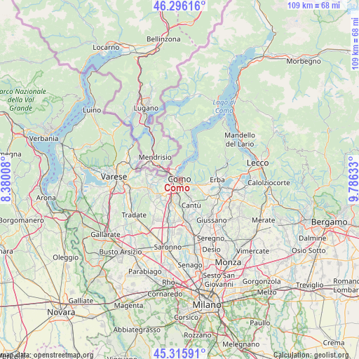
Como GPS coordinates[2]
45° 48' 29.484" North, 9° 4' 59.52" East
| Map corner | latitude | longitude |
|---|---|---|
| Upper-left | 46.29616°, | 8.38008° |
| Center: | 45.80819°, | 9.0832° |
| Lower-right: | 45.31591°, | 9.78633° |
| Map W x H: | 109×109 km | = 67.7×67.7mi |
| max Lat: | 47.04031° ⇑13.9% North |
| Como: | 45.80819° |
| min Lat: | ⇓86.1% South 35.50142° |
| min Long | Como | max Long |
| 6.69888° | 9.0832° | 18.48682° |
| W 20%⇐ | ⇒80% E |
Elevation
Elevation of Como is 213 m = 699 ft, and this is 93.7 m = 307 ft below average elevation for this country.
| Max E: |
2085 m = 6841 ft | 53.6% |
| Avg. | 306.7 m = 1006 ft | |
| Como | 213 m = 699 ft | |
Min E: |
-4 m = -13 ft | 46.4% |
See also: Como elevation on elevation.city.
Geographical zone
Como is located in North temperate zone (between Tropic of Cancer and the Arctic Circle). Distance of this North polar circle is 2307.8 km =1434 mi to North.| Distance of | km | miles | from Como |
|---|---|---|---|
| North Pole | 4913.7 | 3053.2 | to North |
| Arctic Circle | 2307.8 | 1434 | to North |
| Tropic Cancer | 2487.5 | 1545.7 | to South |
| Equator | 5093.4 | 3164.9 | to South |


Nearby cities:
15 places around Como: (largest is in red/bold)
• Blevio
4.1 km =2.5 mi,  24°
24°
• Brunate
1.9 km =1.2 mi,  40°
40°
• Capiago-Intimiano-Olmeda
5.6 km =3.5 mi,  141°
141°
• Cavallasca
3.9 km =2.4 mi,  272°
272°
• Cernobbio
4 km =2.5 mi,  347°
347°
• Grandate
5.1 km =3.2 mi,  206°
206°
• Lipomo
3.3 km =2.1 mi,  120°
120°
• Lucino
4.1 km =2.5 mi,  228°
228°
• Maslianico
4.7 km =2.9 mi,  325°
325°
• Montano
5 km =3.1 mi,  251°
251°
• Montano Lucino
4.2 km =2.6 mi, 229°
• Montorfano
5.3 km =3.3 mi, 117°
• San Fermo della Battaglia
2.8 km =1.7 mi, 271°
• Senna Comasco
5.5 km =3.4 mi,  156°
156°
• Tavernerio
4.5 km =2.8 mi,  100°
100°
Sources, notices
• [Note1] Compared only with cities in Italy existing in our database
• [Src1] Map data: © OpenStreetMap contributors (CC-BY-SA)
• [Src2] Other city data from geonames.org with taken over terms of usage.
• [Src3] Geographical zone / Annual Mean Temperature by Robert A. Rohde @ Wikipedia
