San Michele Tiorre geodata
San Michele Tiorre (Emilia-Romagna) is a populated place; located in Italy in Europe/Rome (GMT+2) time zone. With population of 1,970 people, there are 4214 cities with bigger population in this country. Compared to other cities in Italy, 53.9% of cities are located further ↓South; 65.4% of cities are located further →East and 56.4% of cities have higher elevation than San Michele Tiorre. Note1


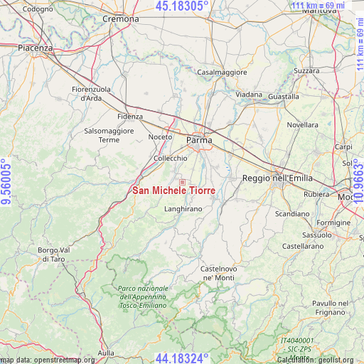
San Michele Tiorre GPS coordinates[2]
44° 41' 7.08" North, 10° 15' 47.412" East
| Map corner | latitude | longitude |
|---|---|---|
| Upper-left | 45.18305°, | 9.56005° |
| Center: | 44.6853°, | 10.26317° |
| Lower-right: | 44.18324°, | 10.9663° |
| Map W x H: | 111.2×111.2 km | = 69.1×69.1mi |
| max Lat: | 47.04031° ⇑46.1% North |
| San Michele Tiorre: | 44.6853° |
| min Lat: | ⇓53.9% South 35.50142° |
| min Long | San Michele Tio | max Long |
| 6.69888° | 10.26317° | 18.48682° |
| W 34.6%⇐ | ⇒65.4% E |
Elevation
Elevation of San Michele Tiorre is 192 m = 630 ft, and this is 114.7 m = 376 ft below average elevation for this country.
| Max E: |
2085 m = 6841 ft | 56.4% |
| Avg. | 306.7 m = 1006 ft | |
| San Michele Tiorre | 192 m = 630 ft | |
Min E: |
-4 m = -13 ft | 43.6% |
See also: Italy elevation on elevation.city.
Geographical zone
San Michele Tiorre is located in North temperate zone (between Tropic of Cancer and the Arctic Circle). Distance of this Northern Tropic circle is 2362.6 km =1468.1 mi to South.| Distance of | km | miles | from San Michele Tiorre |
|---|---|---|---|
| North Pole | 5038.5 | 3130.8 | to North |
| Arctic Circle | 2432.6 | 1511.5 | to North |
| Tropic Cancer | 2362.6 | 1468.1 | to South |
| Equator | 4968.5 | 3087.3 | to South |


Nearby cities:
15 places around San Michele Tiorre: (largest is in red/bold)
• Basilicanova
7.2 km =4.5 mi,  78°
78°
• Carignano
4.7 km =2.9 mi,  10°
10°
• Collecchio
8.3 km =5.2 mi,  333°
333°
• Corcagnano
5.1 km =3.2 mi,  38°
38°
• Felino
2.5 km =1.6 mi,  307°
307°
• Gaiano
8.3 km =5.2 mi,  300°
300°
• Gaione
8.4 km =5.2 mi, 14°
• Langhirano
7.4 km =4.6 mi,  177°
177°
• Lesignano de'Bagni
5.5 km =3.4 mi,  147°
147°
• Mamiano
6.4 km =4 mi,  101°
101°
• Pannocchia
3.8 km =2.4 mi, 104°
• Pilastro
2 km =1.2 mi, 98°
• Sala Baganza
4.5 km =2.8 mi,  319°
319°
• Santa Maria del Piano
5.4 km =3.4 mi,  129°
129°
• Vigatto
6.6 km =4.1 mi,  54°
54°
Sources, notices
• [Note1] Compared only with cities in Italy existing in our database
• [Src1] Map data: © OpenStreetMap contributors (CC-BY-SA)
• [Src2] Other city data from geonames.org with taken over terms of usage.
• [Src3] Geographical zone / Annual Mean Temperature by Robert A. Rohde @ Wikipedia
