Vigatto geodata
Vigatto (Emilia-Romagna) is a populated place; located in Italy in Europe/Rome (GMT+2) time zone. With population of 1,313 people, there are 5588 cities with bigger population in this country. Compared to other cities in Italy, 54.6% of cities are located further ↓South; 64.7% of cities are located further →East and 66.5% of cities have higher elevation than Vigatto. Note1


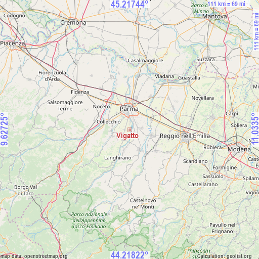
Vigatto GPS coordinates[2]
44° 43' 11.964" North, 10° 19' 49.332" East
| Map corner | latitude | longitude |
|---|---|---|
| Upper-left | 45.21744°, | 9.62725° |
| Center: | 44.71999°, | 10.33037° |
| Lower-right: | 44.21822°, | 11.0335° |
| Map W x H: | 111.1×111.1 km | = 69×69mi |
| max Lat: | 47.04031° ⇑45.4% North |
| Vigatto: | 44.71999° |
| min Lat: | ⇓54.6% South 35.50142° |
| min Long | Vigatto | max Long |
| 6.69888° | 10.33037° | 18.48682° |
| W 35.3%⇐ | ⇒64.7% E |
Elevation
Elevation of Vigatto is 118 m = 387 ft, and this is 188.7 m = 619 ft below average elevation for this country.
| Max E: |
2085 m = 6841 ft | 66.5% |
| Avg. | 306.7 m = 1006 ft | |
| Vigatto | 118 m = 387 ft | |
Min E: |
-4 m = -13 ft | 33.5% |
See also: Italy elevation on elevation.city.
Geographical zone
Vigatto is located in North temperate zone (between Tropic of Cancer and the Arctic Circle). Distance of this Northern Tropic circle is 2366.5 km =1470.5 mi to South.| Distance of | km | miles | from Vigatto |
|---|---|---|---|
| North Pole | 5034.7 | 3128.4 | to North |
| Arctic Circle | 2428.8 | 1509.2 | to North |
| Tropic Cancer | 2366.5 | 1470.5 | to South |
| Equator | 4972.4 | 3089.7 | to South |


Nearby cities:
15 places around Vigatto: (largest is in red/bold)
• Alberi
3.2 km =2 mi,  0°
0°
• Basilicagoiano
6.1 km =3.8 mi,  105°
105°
• Basilicanova
3 km =1.9 mi,  144°
144°
• Botteghino
3.8 km =2.4 mi,  44°
44°
• Carignano
4.5 km =2.8 mi,  279°
279°
• Corcagnano
2.2 km =1.4 mi,  273°
273°
• Gaione
5.3 km =3.3 mi,  323°
323°
• Mamiano
5.2 km =3.2 mi,  169°
169°
• Monticelli Terme
5.2 km =3.2 mi,  79°
79°
• Pannocchia
5.1 km =3.2 mi,  199°
199°
• Pilastrello
3.7 km =2.3 mi,  69°
69°
• Pilastro
5.3 km =3.3 mi,  218°
218°
• Porporano
4 km =2.5 mi,  23°
23°
• San Michele Tiorre
6.6 km =4.1 mi,  234°
234°
• Santa Maria del Piano
7.3 km =4.5 mi,  189°
189°
Sources, notices
• [Note1] Compared only with cities in Italy existing in our database
• [Src1] Map data: © OpenStreetMap contributors (CC-BY-SA)
• [Src2] Other city data from geonames.org with taken over terms of usage.
• [Src3] Geographical zone / Annual Mean Temperature by Robert A. Rohde @ Wikipedia
